|
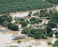
Gainesville FL (SPX) Jun 20, 2007 All eyes are on where hurricanes make landfall, but the massive storms actually cause the most deaths inland, where severe flooding often surprises residents. Now, researchers are learning how to predict where tropical storms and hurricanes will dump the most rain - even days after - and hundreds of miles away from - landfall. In a paper in the current issue of the journal Professional Geographer, Corene Matyas, an assistant professor of geography at the University of Florida, outlines new tools to predict how the storm's intensity, distance it has moved inland and landscape topography alters its "rain shields" - the bands of heavy rain so visible in Doppler radar images. Among other things, her tools proved adept at modeling observations that when hurricanes or tropical storms encounter the Texas hill country or the Appalachian Mountains, their rain shields tend to line up in the same direction and with the same orientation as the underlying topography. "There are a lot of different things that can affect where the rainfall can occur in the storm and how heavy that rainfall will be," Matyas said. "Our goal is to work toward predicting how those factors will determine the rainfall pattern." Historically, hurricanes have proven most fatal at landfall, with coastal residents overcome by storm surge and high winds. But over the past four decades, forecasters have become more skilled at predicting hurricanes' tracks over open water, enabling most coastal residents to flee or prepare for the storms well in advance. As a result, the highest proportion of hurricane and tropical fatalities has shifted inland. One study cited in the Matyas paper found 59 percent of deaths from tropical storms or hurricanes between 1970 and 1999 occurred because of heavy rainfall rather than wind or storm surge. As storms track inland, they inevitably ensnare more cities and towns. In 1998, Tropical Depression Charley left 20 people dead near Del Rio, Texas, more than 200 miles from where the storm made landfall, Matyas notes. Researchers are developing some models for forecasting inland rain patterns, but they have difficulty accounting for the lopsided or elongated shape the pattern often takes, with most if not all rain falling on one side of the storm. A common assumption is that rainfall will decrease as the hurricane moves away from the ocean, which is generally true but may be obviated by other weather systems and local landscape. Matyas' goal was to find new tools to improve the models. She studied radar data from 13 U.S. storms that made landfall between 1997 and 2003, then used a common tool in geography - geographical information systems, or GIS - to measure how rainfall patterns changed. GIS is a computer system that makes it possible to analyze spatial patterns of data. It is often used to track things such as voting patterns, but using GIS in meteorology - where spatial patterns change - is relatively new, Matyas said. Matyas outlined the edge of the rain shields using radar data, then measured their shapes by calculating characteristics such as the position of their center of mass. She repeated the analysis for each hour that the storms were over land. She then used a statistical technique, discriminant analysis, to determine which shape and size best place the storms into groups based on their intensity, how far they travel inland and the topography they encounter. The success of the discriminant analyses indicates that these shape measures could serve as predictive tools for future rainfall models. In a demonstration of the potential, the shape measures helped to confirm that that the orientation of storms' rain shields corresponds closely to the orientation of the land topography. With hurricanes crossing Texas hill country, the rain shields tend to line up parallel to the main axis of the hills, running west to east. Storms near the Appalachians also line up parallel to the mountains, whose axis runs southwest to northeast, with the heaviest rain consistently occurring to the west of the track. This is due to a combination of the mountains and a wedge of cold and dry continental air forcing the moist air upward, causing the water vapor to condense and fall to the ground as rain. This phenomenon does not happen with the Texas storms, as the dry continental air masses over Texas are similar in temperature to tropical moist air masses that accompany hurricanes. Frank Marks, a research meteorologist and director of the National Oceanic and Atmospheric Administration's Hurricane Research Division, said Matyas' conclusions "have a lot of merit in terms of understanding the structure, size and shape of the rain shield." He said the next step is to add rainfall amount to the variables. The end goal: a model that will provide inland residents with the same targeted advance warnings and watches that coastal residents get today - but for heavy rainfall rather than wind or storm surge. Related Links NOAA's Hurricane Research Division Bringing Order To A World Of Disasters When the Earth Quakes A world of storm and tempest
 Austin TX (SPX) Jun 11, 2007
A report that recommends steps to reduce hurricane damage in New Orleans was released by an expert engineering panel of the American Society of Civil Engineers (ASCE). The 84-page report, "The New Orleans Hurricane Protection System: What Went Wrong and Why," targets the public and policymakers, and complements and synthesizes the thousands of pages released so far by the U.S. Army Corps of Engineers during their post-Katrina investigation. |
|
| The content herein, unless otherwise known to be public domain, are Copyright Space.TV Corporation. AFP and UPI Wire Stories are copyright Agence France-Presse and United Press International. ESA Portal Reports are copyright European Space Agency. All NASA sourced material is public domain. Additional copyrights may apply in whole or part to other bona fide parties. Advertising does not imply endorsement, agreement or approval of any opinions, statements or information provided by Space.TV Corp on any Web page published or hosted by Space.TV Corp. Privacy Statement |