|
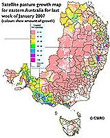
Canberra, Australia (SPX) Feb 08, 2007 CSIRO has just released a new real-time information tool to help graziers in eastern Australia better cope with the impact of climate variations on pasture production. Primary producers from Rockhampton in Queensland across to Ceduna in South Australia and down to Tasmania can now access newly released satellite pasture growth data from the Pastures from Space website here. The Pasture Growth Rate (PGR) data on the website is from the previous weeks' climate records and satellite images which are merged to calculate how fast the pasture is growing at the national, regional, farm and paddock scale. PGR supports farmers in making management decisions like grazing rotation, feed budgeting, fertilizer application and other 'precision' techniques. Because the data is on the web, near real-time decisions can be made. Spatial analyst from CSIRO Armidale, Graham Donald, says PGR provides an assessment of the amount of pasture grown in the last week (in kilograms of dry matter per day). "The major difficulty graziers face with climatic uncertainty is how to match fluctuating feed supply with demand. "It is economically and environmentally vital for producers to manage productivity, meet market demand and maximise profit - but to do this they must utilise their available stock feed strategically and sustainably," Mr Donald said. "These accurate satellite estimations of PGR provide information on feed resources allowing producers to more effectively manage their enterprise and raise the productivity of their businesses," he said. "Producers in eastern Australia now have the tools capable of measuring positive and negative effects on their farms and farming regions generally," Mr Donald said. In providing information about seasonal and yearly fluctuations in pasture production, the Pastures from Space project has also proven invaluable as a decision support tool to shire councils, state government agencies and the banking and finance sectors. CSIRO developed PGR in collaboration with the Western Australia Departments of Food and Agriculture and Land Information (now known as Landgate), with the Bureau of Meteorology providing critical regional climate data. Related Links The latest farming technology and science news Farming Today - Suppliers and Technology
 Canberra, Australia (SPX) Feb 06, 2007
Two recently discovered genes from an ancient wheat variety have led to a major advance in breeding new salt-tolerant varieties. In a recent set of papers published in the journal Plant Physiology researchers describe the two genes - known as Nax1 and Nax2. The genes work by excluding salt from different parts of the plant: one from the roots, the other from the leaves. |
|
| The content herein, unless otherwise known to be public domain, are Copyright Space.TV Corporation. AFP and UPI Wire Stories are copyright Agence France-Presse and United Press International. ESA Portal Reports are copyright European Space Agency. All NASA sourced material is public domain. Additional copyrights may apply in whole or part to other bona fide parties. Advertising does not imply endorsement, agreement or approval of any opinions, statements or information provided by Space.TV Corp on any Web page published or hosted by Space.TV Corp. Privacy Statement |