|
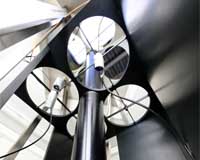
Lausanne, Switzerland (SPX) Aug 29, 2008 On August 26, EPFL, the Swiss National Science Foundation and Switzerland's National Weather service, MeteoSwiss, will inaugurate a new LIDAR measurement system in Payerne, Switzerland. This technically innovative installation, unique in the world, will provide continuous data on aospheric humidity for Western Switzerland's weather forecasting headquarters. To make accurate forecasts, meteorologists need data on the vertical distribution of temperature and humidity in the aosphere. The LIDAR system developed by EPFL can collect these data continuously and automatically up to an altitude of 10km. On August 26, EPFL officially transfered this custom-developed LIDAR to MeteoSwiss, and from this point on Swiss forecasters will have access to this source of vertical humidity data for the models they use to calculate weather predictions. The project was supported by funding from the Swiss National Science Foundation.
One-of-a-kind Swiss know-how This reflection is used to build an instantaneous vertical profile of temperature and humidity. The spatial and temporal resolution is excellent - the laser beam can be shot 30 times per second, a vast improvement over weather balloons that take minutes to reach the upper aosphere and can be sent out only a few times a day. And even though it's state-of-the-art technology, the LIDAR developed by EPFL is stable and reliable; even after a test run of several months, it did not need tuning. Traditional LIDAR systems are more finicky, typically needing to be tuned on a daily basis. According to project leader and EPFL Professor Hubert van den Bergh, "This LIDAR will serve as a reference for future or existing systems, especially since this kind of remote sensing is experiencing rapid development."
An ideal complement to MeteoSwiss' forecasting toolkit It will provide an ideal complement to the traditional instrumentation already in place: a ground-based measurement network, balloon launched radio-soundings, radar equipment, remotely sensed windspeed and temperature measurements, and a station of the Baseline Surface Radiation Network, part of a world-wide network that measures radiation changes at the Earth's surface. The combination of all these measurements will open up new possibilities, and weather forecasting models stand to benefit. The acquisition of the LIDAR will bring high-resolution three-dimensional humidity data to Swiss weather forecasting for the first time. Related Links EPFL Climate Science News - Modeling, Mitigation Adaptation
 Bremerhaven, Germany (SPX) Aug 28, 2008
It is red, it burns and itches: a sunburn on our skin. However, too much sun is not only bad for humans. Many plants react sensitively to an increased dose of ultraviolet radiation, too. Yet they are dependent on sunlight. |
|
| The content herein, unless otherwise known to be public domain, are Copyright Space.TV Corporation. AFP and UPI Wire Stories are copyright Agence France-Presse and United Press International. ESA Portal Reports are copyright European Space Agency. All NASA sourced material is public domain. Additional copyrights may apply in whole or part to other bona fide parties. Advertising does not imply endorsement, agreement or approval of any opinions, statements or information provided by Space.TV Corp on any Web page published or hosted by Space.TV Corp. Privacy Statement |