|
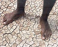
Nairobi, Kenya (SPX) Jan 20, 2009 Responding to sub-Saharan Africa's soil health crisis, the International Center for Tropical Agriculture (CIAT) announced an ambitious new effort to produce the first-ever, detailed digital soil map for all 42 countries of the region. This project combines the latest soil science and technology with remote satellite imagery and on-the-ground efforts to analyze thousands of soil samples from remote areas across the continent to help provide solutions for poor farmers, who suffer from chronically low-yielding crops largely because of degraded soils. Efforts to improve African soils, which are among the most depleted on earth, have been hampered by a lack of up-to-date, comprehensive knowledge about current soil conditions. This information is critical to identify the types and amounts of mineral and organic nutrient sources needed to increase crop yields. The need for action is hard to ignore; according to FAO, one in three people - or 236 million (2007) - in Sub-Saharan Africa are chronically hungry. The African Soil Information Service, or AfSIS, will respond to that need by making up-to-date assessments of soil properties. Researchers will probe the landscape of sub-Saharan Africa, using a variety of highly accurate digital soil mapping techniques to create detailed soil maps, which will be available on the Internet. Data provided by AfSIS at the regional, national and local levels will help farmers and agricultural experts identify the best options for sustainably improving crop production through better soil management. Work on AfSIS is supported through a four-year grant of US$18 million from the Bill and Melinda Gates Foundation and the Alliance for a Green Revolution in Africa (AGRA). CIAT's Nairobi-based Tropical Soil Biology and Fertility (TSBF) Institute will lead the effort. The new digital soil map will ultimately be developed as part of a global soil mapping initiative, called GlobalSoilMap.net. "Soil management in sub-Saharan Africa must be improved dramatically if we are to reduce poverty, feed growing populations and cope with the impact of climate change on agriculture," said Dr. Nteranya Sanginga of CIAT, which is one of 15 centers supported by the Consultative Group on International Agricultural Research (CGIAR). "Achieving this requires accurate, up-to-date information on the state of Africa's soils." "This project will benefit farm families in Africa by showing how they can reverse the trend of declining soil fertility, a major reason for slow growth in the region's agricultural productivity during recent decades," said Dr. Namanga Ngongi, president of AGRA. AfSIS will use innovative remote sensing technology via satellite to create detailed images of large areas indicating nutrients, moisture and organic matter in the soil. It will also use infrared spectroscopy to analyze the chemical and physical properties and organic matter of soil samples. Commonly used in the medical industry, this latter technique is now being used in agriculture, to perform quick assessments of the soil's capacity to retain water and absorb nutrients. All soil information will be collected and made available via the Internet in a user-friendly manner. AfSIS experts will offer training to agricultural extension agents and others on how to interpret and translate information provided by the soil map for practical application. Agricultural policy makers will find the information helpful for developing recommendations about the types, blends and amounts of fertilizers and other soil supplements that are most appropriate for improving harvests in particular regions. The project will pinpoint areas where soils are at risk and provide detailed information on interventions that have proved effective for deterring soil degradation. The data will also provide insights on the environmental and human factors (such as weather patterns and population growth) associated with soil degradation and with the improvement of soil health. "Helping small farmers increase their yields and incomes is one of the most important things that world can do to alleviate hunger and poverty," said Dr. Rajiv Shah, director of Agricultural Development at the Bill and Melinda Gates Foundation. "Access to better information about their soil will empower African farmers to use methods tailored to their conditions so they can boost their productivity and build better lives." Related Links Alliance for a Green Revolution in Africa (AGRA) International Center for Tropical Agriculture (CIAT) Bill and Melinda Gates Foundation Africa News - Resources, Health, Food
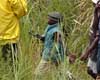 Bujumbura (AFP) Jan 17, 2009
Burundi's FNL rebel group vowed Saturday to release child soldiers in their ranks by the end of January, the latest step in the country's fledgling peace process, an official said. |
|
| The content herein, unless otherwise known to be public domain, are Copyright Space.TV Corporation. AFP and UPI Wire Stories are copyright Agence France-Presse and United Press International. ESA Portal Reports are copyright European Space Agency. All NASA sourced material is public domain. Additional copyrights may apply in whole or part to other bona fide parties. Advertising does not imply endorsement, agreement or approval of any opinions, statements or information provided by Space.TV Corp on any Web page published or hosted by Space.TV Corp. Privacy Statement |