 |
|
by Staff Writers Tokyo, Japan (SPX) May 02, 2016
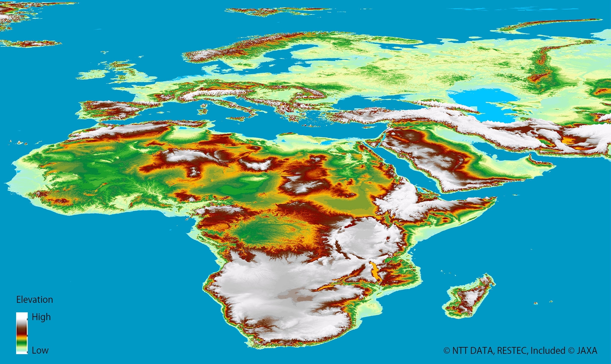
NTT DATA and the Remote Sensing Technology Center of Japan (RESTEC) have announced that their global digital 3D map service, AW3DTM, became the world's first five-meter-resolution 3D map covering all global land spaces, including Antarctica. AW3DTM, the world's most precise global 3D map service, uses a digital elevation model (DEM) with five-meter resolution based on some three million satellite images taken by the DAICHI Advanced Land Observing Satellite (ALOS) of the Japan Aerospace Exploration Agency (JAXA). NTT DATA and RESTEC launched a digital 3D map distribution service covering limited areas of the world in February 2014. The service was a great improvement on existing 3D world maps, which offered resolutions of up only 30 or 90 meters. AW3DTM has been used in over 60 countries. NTT Data and RESTEC have steadily expanded the areas of coverage, culminating in the newly announced completion of all terrestrial areas on earth. "Our AW3DTM global digital 3D map service, thanks to its high-detail five-meter resolution covering the entire world, will provide new data for greater insight into global issues," said Ken Tsutsui, project leader of the 3D Atlas initiative at NTT DATA. "We expect that customers will use the service to address needs in infrastructure, transportation, disaster prevention and much more. In particular, we believe that AW3DTM could help emerging countries to advance their infrastructure development." Specific applications could include identifying areas vulnerable to tsunamis or landslides caused by large earthquakes, devising global-scale construction plans of multinational companies, improving global-scale traffic simulation or navigation for air and ground transportation, streamlining resource and energy studies and logistics, and evaluating climate-change risks due to rising seas or glacial melting. AW3DTM is available to individuals, companies or organizations that require map data covering specific geographic areas. Prices are available upon request. "NTT DATA and RESTEC are delighted to support global needs for highly detailed topographic information with the AW3DTM global digital 3D map service," said Kazuo Isono, project manager at RESTEC. "Going forward, we expect the service to create new markets for digital map services and related fields, especially as we incorporate additional geographical information and systems to respond to ever-wider needs worldwide." In addition to the standard AW3DTM global digital 3D map service with five-meter resolution, NTT DATA and RESTEC are also launching enhanced and building-focused services using high resolution satellite imagery. The enhanced service offers a high-definition and high-resolution 3D map at half-meter or two-meter resolution, both of which are offered on an on-demand basis. The building-focused service utilizes satellite images shot in near proximity to offer highly detailed pictures of structures and their heights in a vector-map format suitable for simulations, such as those identifying areas of co-channel interference or analyzing site perspectives for construction projects. The service covers buildings in Japan, while those outside of Japan are available on demand.
Related Links NTT DATA Earth Observation News - Suppiliers, Technology and Application
|
|||||||||||||
|
|
| The content herein, unless otherwise known to be public domain, are Copyright 1995-2024 - Space Media Network. All websites are published in Australia and are solely subject to Australian law and governed by Fair Use principals for news reporting and research purposes. AFP, UPI and IANS news wire stories are copyright Agence France-Presse, United Press International and Indo-Asia News Service. ESA news reports are copyright European Space Agency. All NASA sourced material is public domain. Additional copyrights may apply in whole or part to other bona fide parties. All articles labeled "by Staff Writers" include reports supplied to Space Media Network by industry news wires, PR agencies, corporate press officers and the like. Such articles are individually curated and edited by Space Media Network staff on the basis of the report's information value to our industry and professional readership. Advertising does not imply endorsement, agreement or approval of any opinions, statements or information provided by Space Media Network on any Web page published or hosted by Space Media Network. General Data Protection Regulation (GDPR) Statement Our advertisers use various cookies and the like to deliver the best ad banner available at one time. All network advertising suppliers have GDPR policies (Legitimate Interest) that conform with EU regulations for data collection. By using our websites you consent to cookie based advertising. If you do not agree with this then you must stop using the websites from May 25, 2018. Privacy Statement. Additional information can be found here at About Us. |

 del.icio.us
 Digg
Digg Reddit
 Google