 |
Greenbelt MD (SPX) Jun 09, 2010 The Tropical Rainfall Measuring Mission satellite, known as TRMM is a "flying rain gauge" in space, and can provide rainfall estimates from its position in orbit around the Earth. Data accumulated from TRMM enabled visualizers to create a map of rainfall generated by Cyclone Phet as it marched through the Arabian Sea from May 31 to June 6. The heaviest rainfall occurred over open waters, but Phet dropped very heavy rainfall over parts of Oman and Pakistan. TRMM satellite rainfall data estimated Cyclone Phet's heaviest rainfall (600 or more millimeters/23.6 or more inches) occurred over open waters of the Arabian Sea. One area of northeast Oman received as much as 450 millimeters (17.7 inches), while Pakistan received between 150-300 millimeters/ 5.9-11.8 inches as Phet made landfall there this past weekend. NASA's Jesse Allen created a rainfall image is based on data from the Multi-satellite Precipitation Analysis (MPA) produced at NASA's Goddard Space Flight Center in Greenbelt, Md. The image showed both rainfall amounts and the storm track for Phet from May 31 to June 6, 2010. The MPS analysis estimates rainfall by combining measurements from many satellites and calibrating them using rainfall measurements from the Tropical Rainfall Measuring Mission (TRMM) satellite. Tropical Cyclone Phet brought not just strong winds but also heavy rains to the Arabian Sea, the Arabian Peninsula, and the coast of Pakistan in late May and early June. Phet reached its greatest intensity off the coast of Oman on June 3. After making landfall in Oman, Phet dissipated somewhat, but remained organized enough to move back over the Arabian Sea toward Pakistan.
Share This Article With Planet Earth
Related Links NASA/Goddard Space Flight Center Earth Observation News - Suppiliers, Technology and Application
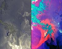 NASA Images Show Oil's Invasion Along Louisiana Coast
Pasadena CA (JPL) Jun 04, 2010 These images, acquired on May 24, 2010 by the Multi-angle Imaging SpectroRadiometer (MISR) instrument aboard NASA's Terra spacecraft, show the encroachment of oil from the former Deepwater Horizon rig into Louisiana's wildlife habitats. The source of the spill is located off the southeastern (bottom right) edge of the images. Dark filaments of oil are seen approaching the shores of Blind B ... read more |
|
| The content herein, unless otherwise known to be public domain, are Copyright 1995-2010 - SpaceDaily. AFP and UPI Wire Stories are copyright Agence France-Presse and United Press International. ESA Portal Reports are copyright European Space Agency. All NASA sourced material is public domain. Additional copyrights may apply in whole or part to other bona fide parties. Advertising does not imply endorsement,agreement or approval of any opinions, statements or information provided by SpaceDaily on any Web page published or hosted by SpaceDaily. Privacy Statement |


 del.icio.us
 Digg
Digg Reddit
 YahooMyWeb
 Google