|
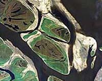
Greenbelt MD (SPX) Sep 06, 2007 Using data from instruments aboard NASA satellites, Zhiqiang Chen and colleagues at the University of South Florida in St. Petersburg, found that they can monitor water quality almost daily, rather than monthly. Such information has direct application for resource managers devising restoration plans for coastal water ecosystems and federal and state regulators in charge of defining water quality standards. The team's findings, published July 30 in two papers in Remote Sensing of Environment, will help tease out factors that drive changes in coastal water quality. For example, sediments entering the water as a result of coastal development or pollution can cause changes in water turbidity - a measure of the amount of particles suspended in the water. Sediments suspended from the bottom by strong winds or tides may also cause such changes. Knowing where the sediments come from is critical to managers because turbidity cuts off light to the bottom, thwarting the natural growth of plants. "If we can track the source of turbidity, we can better understand why turbidity is changing. And if the source is human-related, we can try to manage that human activity," says Frank Muller-Karger, a study co-author from the University of South Florida. Satellites previously have observed turbidity in the open ocean by monitoring how much light is reflected and absorbed by the water. The technique has not had much success in observing turbidity along the coast, however. That's because shallow coastal waters and Earth's atmosphere serve up complicated optical properties that make it difficult for researchers to determine which colors in a satellite image are related to turbidity, which to shallow bottom waters, and which to the atmosphere. Now with advances in satellite sensors combined with developments in how the data are analyzed, Chen and colleagues show it is possible to monitor turbidity of coastal waters via satellite. The traditional methods of monitoring coastal water quality require scientists to use boats to gather water samples, typically on a monthly basis because of the high costs of these surveys. The method is sufficient to capture episodic events affecting water quality, such as seasonal freshwater runoff. Chen and colleagues suspected, however, that the monthly measurements were not capturing fast changes in factors that affect water quality, such as winds, tides and human influences including pollution and runoff. The team set out to see if satellites could accurately measure two key indicators of water quality - turbidity and water clarity - in Tampa Bay, Fla. An analysis of turbidity takes into account water clarity, a measure of how much light can penetrate into deep water. Satellites, with their wide coverage and multiple passes per week, provided a solution to frequent looks and measuring an entire estuary within seconds. To determine water clarity in Tampa Bay, the team looked at more than eight years of imagery from GeoEYE's Sea-viewing Wide Field-of-view Sensor (SeaWiFS) instrument, whose data is analyzed, processed and distributed by NASA for research. The images give a measure of how much light is reflected by the water. The data were put through a two-step calculation to arrive at a measure of clarity. Similarly, data from NASA's Moderate Resolution Imaging Spectroradiometer (MODIS) instrument onboard the Aqua satellite was compared with measurements of turbidity gathered on the ground and then applied to each whole image to make the maps. When compared with results from independent field measurements, collected with the help from the U.S. Geological Survey, the researchers found that the satellites offered an accurate measure of water quality in the bay. The method can be applied to coastal waters worldwide with little change in methods, according to Muller-Karger. Frequent measurements from space could resolve questions about the specific timing and nature of events that led to decreases in water quality. Seasonal freshwater discharge from nearby rivers and runoff into the bay can carry nutrients. If these nutrients are not controlled, they can give rise to large and harmful phytoplankton blooms, which can kill sea grass. Wind conditions, however, are the driving force for a decline in water quality in the dry season between October and June, when bottom sediments are disturbed. "It's important to look at baseline conditions and see how they change with the seasons and over the years, and whether that change is due to development, coastal erosion, the extraction and dumping of sediments, or digging a channel," Muller-Karger says. The SeaWiFS sensor was launched aboard the OrbView-2 satellite in 1997 to collect ocean color data. MODIS was launched aboard the Aqua satellite in 2002. The instrument collects measurements from the entire Earth surface every one to two days. Related Links NASA/Goddard Space Flight Center Water News - Science, Technology and Politics
 Moscow (RIA Novosti) Aug 28, 2007
On the summer's last Sunday, Russia is celebrating the Day of Lake Baikal. This tradition was started in 1999 by the public organization Baikal Environmental Wave. By that time, it was already a UNESCO World Heritage site as a masterpiece of nature and the global strategic freshwater resource. Baikal is flanked by the Republic of Buryatia, the Irkutsk and Chita regions, where celebrations of its holiday are particularly glamorous. |
|
| The content herein, unless otherwise known to be public domain, are Copyright Space.TV Corporation. AFP and UPI Wire Stories are copyright Agence France-Presse and United Press International. ESA Portal Reports are copyright European Space Agency. All NASA sourced material is public domain. Additional copyrights may apply in whole or part to other bona fide parties. Advertising does not imply endorsement, agreement or approval of any opinions, statements or information provided by Space.TV Corp on any Web page published or hosted by Space.TV Corp. Privacy Statement |