|
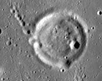
Moffett Field CA (SPX) Sep 20, 2007 New higher resolution lunar imagery and maps including NASA multimedia content now are available on the Google Moon Web site. Updates include new content from the Apollo missions, including dozens of embedded panoramic images, links to audio clips and videos, and descriptions of the astronauts' activities during the missions. The new content is overlaid on updated, higher-resolution lunar maps. Also added are detailed charts of different regions of the moon suitable for use by anyone simulating a lunar mission. "NASA's objective is for Google Moon to become a more accurate and useful lunar mapping platform that will be a foundation for future web-based moon applications, much like the many applications that have been built on top of Google Maps," said Chris C. Kemp, director of strategic business development at NASA's Ames Research Center, Moffett Field, Calif. "This will make it easier for scientists everywhere to make lunar data more available and accessible." Google Moon's visible imagery and topography are aligned with the recently updated lunar coordinate system and can be used for scientifically accurate mission planning and data analysis. The new site is designed to be user-friendly and encourage the exchange of data and ideas among scientists and amateur astronomers. This announcement closely follows the release of new NASA content in Google Earth, including photographs taken by NASA astronauts and imagery from NASA's Earth observing satellite sensors, such as the Sea-viewing Wide Field of View Sensor, Landsat and the Moderate Resolution Imaging Spectrometer. Astronaut photography was developed in collaboration with the Crew Earth Observations team, part of the Image Science and Analysis Laboratory at NASA's Johnson Space Center, Houston. Satellite imagery of Earth was developed in partnership with the Earth Observatory team at NASA's Goddard Space Flight Center, Greenbelt, Md. The alliance was accomplished under a Space Act Agreement signed in December 2006 by Google and NASA's Ames Research Center. Google is headquartered near Ames in northern California's Silicon Valley.
For more information on Google Moon, visit: http://moon.google.com For more information on Google Earth, visit: http://earth.google.com Related Links Mars News and Information at MarsDaily.com Lunar Dreams and more
 Moscow (RIA Novosti) Sep 19, 2007
On September 17, international reports confirmed the seriousness of Beijing's intention to put its own spacecraft in a lunar orbit before the end of this year. While for the leading space players - Russia and the United States - planned expeditions are quite natural if not always justified, China's lunar ambition, and indeed the country's entire space effort, fills one with wonder at such an extraordinary display of daring. But lunar programs exist in many countries, and nothing can save our natural satellite from colonization. |
|
| The content herein, unless otherwise known to be public domain, are Copyright Space.TV Corporation. AFP and UPI Wire Stories are copyright Agence France-Presse and United Press International. ESA Portal Reports are copyright European Space Agency. All NASA sourced material is public domain. Additional copyrights may apply in whole or part to other bona fide parties. Advertising does not imply endorsement, agreement or approval of any opinions, statements or information provided by Space.TV Corp on any Web page published or hosted by Space.TV Corp. Privacy Statement |