|
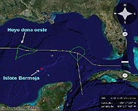
Mexico City (AFP) Feb 11, 2009 Lawmakers in Mexico are trying to determine the whereabouts of island central to the country's oil claims, which appears literally to have dropped off the map about 10 years ago. Bermeja island in the Gulf of Mexico -- a strategic marker defining US and Mexican maritime and subsea rights -- has disappeared along with documents backing up a bilateral treaty on major oil reserves in the area, fueling rumors of a CIA plot. "There are two stories about how it disappeared: one is that global warming raised the sea level and it is under water," said Mexican lawmaker Elias Cardenas, of the Convergence Party. "The other is that ... it was blown up by the CIA so that the United States would get the upper hand in Hoyos de Dona" -- the oil reserves area. Low-lying Bermeja, a smallish 80 km2 (31 sq miles), until 30 years ago was the official land point from which Mexico set its 200 nautical-mile economic zone. The Alacranes islands now are being used as the marker, sharply reducing Mexico's economic zone. In June 2000, Mexico and the United States signed a treaty putting a 10-year moratorium on their prospecting and pumping activities in the area. It is set to expire in 2011. But "we do not have information about how this accord was signed," Cardenas said, while Bermeja north of Yucatan and Campeche states, had been mapped as far back as 1669. Bermeja appears in a 1998 book of Mexican islands by the Interior Ministry, but in 1997 a Navy fishing expedition reported it could not locate the island, Cardenas said. The foreign ministry did not respond to an AFP request for comment on the case. Miguel Angel Gonzalez Felix, a foreign ministry legal adviser when the treaty was negotiated, last June told senators the island was some 40 to 50 meters (120 to 150 feet) under water. Six days later, several Mexican senators said in a statement that "a force of nature (able to sink an island) does not take place without anyone noticing, and much less so when it is sitting in an area with more than 22 billion barrels of oil reserves." Lawmakers have demanded President Felipe Calderon account for how Bermeja Island disappeared from Mexican territory. Related Links Powering The World in the 21st Century at Energy-Daily.com
 Washington DC (UPI) Feb 10, 2009
This week's meeting of the Iraqi Oil Ministry with international oil companies in Istanbul begins a three-month series of gatherings, organized by the government or government workers, aimed at clearing through the turmoil of revitalizing Iraq's oil and gas sector. |
|
| The content herein, unless otherwise known to be public domain, are Copyright Space.TV Corporation. AFP and UPI Wire Stories are copyright Agence France-Presse and United Press International. ESA Portal Reports are copyright European Space Agency. All NASA sourced material is public domain. Additional copyrights may apply in whole or part to other bona fide parties. Advertising does not imply endorsement, agreement or approval of any opinions, statements or information provided by Space.TV Corp on any Web page published or hosted by Space.TV Corp. Privacy Statement |