|
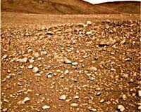
Marshalltown IA (SPX) Mar 06, 2008 Mechdyne has announced that it has installed an immersive CAVE display system as the focal point of the new Fossett Laboratory for Virtual Planetary Exploration at Washington University St. Louis (WUSTL). As a teaching and research facility of the Department of Earth and Planetary Sciences, the Laboratory will provide 3D imaging capability for visualization of data collected by national and international space exploration programs. One highlight of the Fossett Laboratory's work in 2008 will be immersive visualizations of imagery gathered as part of the ongoing Mars Exploration Program. The new CAVE system supports stereoscopic projection on three walls and the floor (each 7.5' h x 10' w) to create a surround screen environment. Mechdyne integrated its Beacon projection technology along with a wireless motion tracking system and virtual wand that allows scientists to easily 'fly' through visualizations. Mechdyne also provided its CAVELib software and Conduit for ArcGIS, which is used to 3D-enable data to create a fully immersive, virtual reality experience in the CAVE. "The CAVE system installed in the Fossett Laboratory brings a unique capability to faculty, students and guest researchers working to interpret data from man's exploration of planetary bodies throughout the solar system," said Professor Raymond Arvidson, chair of the Department of Earth and Planetary Sciences at WUSTL. "We can effectively transport groups of people to the surface of other planets and create experiences that will illuminate and enhance understanding of the geology and geophysics both of other planets and our own home." The Laboratory, which was funded through a gift from noted adventurer and WUSTL alumnus Steve Fossett, is an important addition to the Earth and Planetary Sciences facilities at WUSTL. The Lab includes the CAVE system, housed in a purpose-built room, along with a graphics computing cluster based on HP quad-processor servers and NVidia graphics. Washington University is home to the Geosciences Node of the NASA Planetary Data System, with responsibility for management of data related to the study of the surfaces and interiors of terrestrial planetary bodies. For the Mars visualizations, researchers at the Fossett Laboratory will draw on data from such missions as Mars Global Surveyor, 2001 Mars Odyssey, the Mars Exploration Rovers, Mars Reconnaissance Orbiter and Phoenix. WUSTL houses more than 10 TB (Terabytes) of data collected in various NASA missions, including hyperspectral imagery gathered by orbital systems and landers. The facility also has access to visual imagery from other PDS nodes, which will be combined with spectral data to provide data rich imagery. "Tools such as the CAVE are necessary not only to help us better understand the data we are collecting but also to help draw the best and brightest new students to the field of planetary sciences," said Keith Bennett, Deputy Manager for Operations of the PDS Geosciences Node. "This may be the first planetary geosciences facility in the world with a dedicated 'virtual reality' imaging center, giving us the potential to perform first-of-its-kind work in data integration and analysis. During the next few months, we will be evaluating techniques for working with the data to get the most out of the unique capability of the visualization environment." Related Links Mechdyne Mars News and Information at MarsDaily.com Lunar Dreams and more
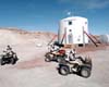 Boston MA (SPX) Feb 27, 2008
Last week, two MIT students began living, working and communicating with the outside world as if they were on a mission to Mars. Whenever they go outside their small, round habitat where eight people are spending a two-week "mission," they don spacesuits and pass through an airlock. |
|
| The content herein, unless otherwise known to be public domain, are Copyright Space.TV Corporation. AFP and UPI Wire Stories are copyright Agence France-Presse and United Press International. ESA Portal Reports are copyright European Space Agency. All NASA sourced material is public domain. Additional copyrights may apply in whole or part to other bona fide parties. Advertising does not imply endorsement, agreement or approval of any opinions, statements or information provided by Space.TV Corp on any Web page published or hosted by Space.TV Corp. Privacy Statement |