|
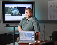
Athens GA (SPX) Jan 17, 2008 Tracking the location and availability of resources such as hospitals, transportation equipment and water during an emergency situation can be life-saving. A collaborative mapping tool developed by the Georgia Tech Research Institute (GTRI) is helping emergency management officials better coordinate event and incident planning - and real-time response. GTRI has teamed with Atlanta-based company Emergency Visions to provide mapping capabilities for a resource database the firm developed to identify, activate, track and coordinate response assets. The GTRI and Emergency Visions applications were selected by the Florida Division of Emergency Management in June 2007 as part of a solution that combines these comprehensive technology tools with the training and management expertise of a team led by the International City/County Management Association (ICMA). "A lot of mapping systems are pretty complex to operate. Our system was deliberately designed to be easy to use for people who are not mapping experts," said Kirk Pennywitt, a senior research engineer in GTRI's Information Technology and Telecommunications Laboratory (ITTL). Researchers began developing the Geographic Tool for Visualization and Collaboration (GTVC) in 2000 for military applications, but it has since been tailored to the needs of the emergency management community and first responders. GTVC can track chemical or smoke plumes and help management personnel plan evacuation routes for emergencies such as hurricanes, fires or flooding. To do this, the system tracks resources including the locations of hospitals, fire stations, schools, nursing homes, sand bags, dump trucks, water, personnel and supplies in an affected region. The map can also indicate the status of those assets, such as the number of beds available in a specific hospital. Emergency planners can immediately get a snapshot of what is going on without relying solely on traditional voice communications. The symbols displayed on the map are the Department of Homeland Security's official emergency management icons. During an event, electronic feeds can alert users to new incidents and display the location of the events live on the map. Also, GTVC records every user's actions so that those in command can review them after the event to improve planning for future events. Pennywitt's software development team spent two months improving GTVC to provide Florida with new capabilities - including real-time tracking of resources. Researchers also included the ability to: Track mobile assets with the global positioning system (GPS) Manage warehouse resources Display real-time availability of a resource Aggregate multiple resources in the same location with a single icon Simultaneously show location coordinates in multiple formats, such as latitude/longitude and military grid reference system Update the status of a resource by clicking on its map icon as an alternative to using the database interface "We will soon be adding an option to allow users to provide their own custom topographic, photographic or aerial maps," explained Pennywitt. Currently, users can view street maps, aerial imagery or a combination of both. The combined mapping and database system provides Florida with a robust networked emergency management system that it plans to implement in all 67 of the state's counties. The Georgia Emergency Management Agency has been using the system since 2005 to track forest fires and hurricanes. Hillsborough County, Florida and Dakota County, Minnesota have also licensed the emergency management software for their incident preparedness plans. "We've also had interest from more than 100 other cities, counties and local agencies," added Pennywitt. Related Links Georgia Institute of Technology Research News Bringing Order To A World Of Disasters A world of storm and tempest When the Earth Quakes
 Bantul, Indonesia (AFP) Jan 16, 2008
With every step he takes, Sukasdi feels a shard of pain shoot down his back, reminding him of the day two years ago that a powerful earthquake destroyed his home and broke his spine. |
|
| The content herein, unless otherwise known to be public domain, are Copyright Space.TV Corporation. AFP and UPI Wire Stories are copyright Agence France-Presse and United Press International. ESA Portal Reports are copyright European Space Agency. All NASA sourced material is public domain. Additional copyrights may apply in whole or part to other bona fide parties. Advertising does not imply endorsement, agreement or approval of any opinions, statements or information provided by Space.TV Corp on any Web page published or hosted by Space.TV Corp. Privacy Statement |