|
Salt Lake City UT (SPX) Aug 11, 2008 Magellan will showcase its Fall 2008 outdoor and vehicle navigation lineup at the 2008 Outdoor Retailer Summer show, featuring the latest in design, ease-of-use, content, and accessibility. Offerings include the Intermap Technologies comprehensive AccuTerra maps, and the Magellan Triton Series AdventurePack, which includes one of five Triton units, National Geographic's TOPO! Explorer Deluxe map software, carrying case, and Secure Digital (SD) memory card.
Now Triton Users Can Access More National Geographic Maps on Their Device Now the Triton series is the first outdoor handheld to offer users access to National Geographic's new TOPO! Explorer Deluxe map software. National Geographic TOPO! Explorer Deluxe supports the Magellan Triton 300, 400, 500, 1500 and 2000 units and offers outdoor enthusiasts: + Detailed map imagery -- enabling users to view USGS 1:24k (7.5 Minute) quads + Natural color aerial imagery + Access to an online database filled with trails, Forest Service roads, and other recreational information
Triton AdventurePack TOPO! Explorer Deluxe is an entirely new way to get detailed topographic maps for hiking, cycling, backpacking, camping, hunting, fishing, and more. TOPO! Explorer Deluxe contains 25 map credits for use on the TOPO! Explorer web site The map credits entitle customers to download 25 SuperQuads for any location in the United States. TOPO! Explorer Deluxe also includes a nationwide set of USGS 1:100,000 -- scale topographic maps, ideal for planning trips and browsing terrain. The Triton AdventurePack series brings these two products together, combining them with Magellan's rugged IPX-7 design, a color touch screen (some units), handy carrying case and SD memory card, putting the next adventure in the palm of the user's hand. These solutions will be demonstrated at Outdoor Retailer, so retailers can test for themselves.
AccuTerra Maps Triton and AccuTerra offer detailed land use classifications that outline federal, state, and local lands, plus a linear trail network and over 1 million outdoor-centric POIs for the most comprehensive recreational content available for handheld GPS. The Triton series and AccuTerra maps will also be demonstrated together, giving retailers another hands-on testing opportunity.
VantagePoint Map and Content Management Applications
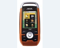
Triton Series The full-featured Triton units offer full-color, touch-screen controls and a built-in 2 mega pixel camera, which gives users the ability to record and attach audio/video and photographs to waypoint files. IPX-7 rated and water submersible, the Triton series delivers ruggedness required by even the most demanding outdoor enthusiast. Other unique Triton features include a digital compass (electronic on some models), barometer and built-in LED flashlight. All of these features are elegantly integrated and designed to create an overall experience not found in any outdoor GPS handheld today. Related Links Magellan TOPO! Explorer GPS Applications, Technology and Suppliers
 San Diego CA (SPX) Jul 16, 2008
Researchers at San Diego State University have developed a new concept for improving MEMS accelerometer tunability. This method can increase wide-band tunability with ranges much larger than current practice, a significant improvement from the previously accepted 5-10%. |
|
| The content herein, unless otherwise known to be public domain, are Copyright Space.TV Corporation. AFP and UPI Wire Stories are copyright Agence France-Presse and United Press International. ESA Portal Reports are copyright European Space Agency. All NASA sourced material is public domain. Additional copyrights may apply in whole or part to other bona fide parties. Advertising does not imply endorsement, agreement or approval of any opinions, statements or information provided by Space.TV Corp on any Web page published or hosted by Space.TV Corp. Privacy Statement |