|
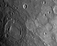
Baltimore MD (SPX) Jan 18, 2008 Shortly following MESSENGER's closest approach to Mercury on January 14, 2008, the spacecraft's Narrow Angle Camera (NAC) on the Mercury Dual Imaging System (MDIS) instrument acquired this image as part of a mosaic that covers much of the sunlit portion of the hemisphere not viewed by Mariner 10. Images such as this one can be read in terms of a sequence of geological events and provide insight into the relative timing of processes that have acted on Mercury's surface in the past. The double-ringed crater pictured in the upper right of this image appears to be filled with smooth plains material, perhaps volcanic in nature. This crater was subsequently disrupted by the formation of a prominent scarp (cliff), the surface expression of a major crustal fault system, that runs alongside part of its southern rim and may have led to the uplift seen across a portion of the crater's floor. A smaller crater in the upper left of the image has also been cut by the scarp, showing that the fault beneath the scarp was active after both of these craters had formed. The MESSENGER team is working to combine inferences about the timing of events gained from this image with similar information from the hundreds of other images acquired by MESSENGER to extend and refine the geological history of Mercury previously defined on the basis only of Mariner 10 images. This MESSENGER image was taken from a distance of about 18,000 kilometers (11,000 miles) from the surface of Mercury, at 20:03 UTC, about 58 minutes after the closest approach point of the flyby. The region shown is about 500 kilometers (300 miles) across, and craters as small as 1 kilometer (0.6 mile) can be seen in this image. Related Links News Flash at Mercury Mars News and Information at MarsDaily.com Lunar Dreams and more
 Baltimore MD (SPX) Jan 17, 2008
As NASA's MESSENGER spacecraft approached Mercury on January 14, 2008, it captured this view of the planet's rugged, cratered landscape illuminated obliquely by the sun. This image was taken from a distance of approximately 11,000 miles, about 56 minutes before the spacecraft's closest encounter with Mercury. |
|
| The content herein, unless otherwise known to be public domain, are Copyright Space.TV Corporation. AFP and UPI Wire Stories are copyright Agence France-Presse and United Press International. ESA Portal Reports are copyright European Space Agency. All NASA sourced material is public domain. Additional copyrights may apply in whole or part to other bona fide parties. Advertising does not imply endorsement, agreement or approval of any opinions, statements or information provided by Space.TV Corp on any Web page published or hosted by Space.TV Corp. Privacy Statement |