|
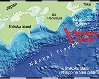
Chicago IL (SPX) Feb 19, 2009 Deep-sea drilling into one of the most active earthquake zones on the planet is providing the first direct look at the geophysical fault properties underlying some of the world's largest earthquakes and tsunamis. The Nankai Trough Seismogenic Zone Experiment (NanTroSEIZE) is the first geologic study of the underwater subduction zone faults that give rise to the massive earthquakes known to seismologists as mega-thrust earthquakes. "The fundamental goal is to sample and monitor this major earthquake-generating zone in order to understand the basic mechanics of faulting, the basic physics and friction," says Harold Tobin, University of Wisconsin-Madison geologist and co-chief scientist of the project. Tobin will present results from the first stage of the project Sunday, Feb. 15, at the 2009 American Association for the Advancement of Science meeting in Chicago. Subduction zone faults extend miles below the seafloor and the active earthquake-producing regions - the seismogenic zones - are buried deep in the Earth's crust. The NanTroSEIZE project, an international collaboration overseen by the Integrated Ocean Drilling Program, is using cutting-edge deep-water drilling technology to reach these fault zones for the first time. "If we want to understand the physics of how the faults really work, we have to go to those faults in the ocean," Tobin explains. "Scientific drilling is the main way we know anything at all about the geology of the two-thirds of the Earth that is submerged." The decade-long project, to be completed in four stages, will use boreholes, rock samples, and long-term in situ monitoring of a fault in the Nankai Trough, an earthquake zone off the coast of Japan with a history of powerful temblors, to understand the basic fault properties that lead to earthquakes and tsunamis. The project is currently is its second year. Subduction zone faults angle upward as one of the giant tectonic plates comprising Earth's surface slides below another. Tremendous friction between the plates builds until the system faults and the accumulated energy drives the upper plate forward, creating powerful seismic waves that make the crust shake and can produce a tsunami. But although both shallow and deep parts of the fault slip, only the deep regions produce earthquakes. During the first stage of the project, the team found evidence of extensive rock deformation and a highly concentrated slip zone even in shallow regions that do not generate earthquakes. One rock core from a shallow part of the fault contains a narrow band of finely ground "rock flour" revealing a fault zone between the upper and lower plates that is only about two millimeters thick - roughly the thickness of a quarter. Above deeper portions of the fault, the team discovered layers of displaced rock and evidence of prolonged seismic activity that suggest a region known as the megasplay fault is likely responsible for the largest tsunami-generating plate slips. "A fundamental goal was to understand how the faults at depth connect up toward the Earth's surface, and we feel that we've discovered the fault zone that's the main culprit," Tobin says. The next stage of drilling will commence this May, with plans to drill additional boreholes into the plate above deep regions of the fault zone. In addition to collecting cores for comparison to those from shallower parts of the fault, the scientists will install sensors in these holes to set up a deep-sea observatory monitoring physical stresses, movement, temperature and pressure. Related Links University of Wisconsin-Madison Tectonic Science and News
 Seattle WA (SPX) Feb 05, 2009
In the last decade, scientists have recorded regular episodes of tectonic plates slowly, quietly slipping past each other in western Washington and British Columbia over periods of two weeks or more, releasing as much energy as a magnitude 6 earthquake. |
|
| The content herein, unless otherwise known to be public domain, are Copyright Space.TV Corporation. AFP and UPI Wire Stories are copyright Agence France-Presse and United Press International. ESA Portal Reports are copyright European Space Agency. All NASA sourced material is public domain. Additional copyrights may apply in whole or part to other bona fide parties. Advertising does not imply endorsement, agreement or approval of any opinions, statements or information provided by Space.TV Corp on any Web page published or hosted by Space.TV Corp. Privacy Statement |