 |
Moscow (AFP) April 8, 2010 A satellite to study how climate change affects Earth's icecaps finally launched into space Thursday five years after a first attempt failed, the European Space Agency (ESA) announced. The 700-kilo (1,540 pound) CryoSat-2 module lifted off at 15:57 GMT on a Dnepr rocket from the Baikonur Cosmodrome in Kazakhstan, separating from the launcher 17 minutes later. Its mission is to measure changes in the thickness of the vast ice sheets that overlie Antarctica and Greenland, as well as variations in the thickness of the relatively thin ice floating in the polar oceans. CryoSat-2 replaces the original CryoSat satellite lost in 2005 during a launch failure. For climate physicists, ice cover is like a canary in a coal mine, providing invaluable early warning of the impacts of man-made temperature rise. Over the past decade, mounting evidence points to the loss of floating summer sea ice in the Arctic and the breakup of large banks of ice on the Antarctic peninsula as global warming has intensified. But much remains unknown, especially the health of the Greenland and Antarctic land ice sheets, where the bulk of the planet's fresh water is locked up. Even a small melt from these mighty frozen reservoirs could drive up sea levels sufficiently to drown many coastal cities and deltas, forcing hundreds of millions of people to higher ground. "We know from our radar satellites that sea ice extent is diminishing, but there is still an urgent need to understand how the volume of ice is changing," said Volker Liebig, ESA's Director of Earth Observation Programmes. "To make these calculations, scientists also need information on ice thickness." The big tool for measuring the ice is CryoSat-2's specially-designed all-weather microwave radar altimeter, capable of detecting changes in ice thickness to within one centimetre (0.4 of an inch). CryoSat-2 is the third so-called "Earth Explorer" satellite put into orbit by the European agency in just over a year. The Gravity field and Ocean Circulation Explorer (GOCE) mission launched in March 2009, and the Soil Moisture and Ocean Salinity (SMOS) mission followed in November. All three missions are designed to study the effect of human activity on Earth's natural processes. Safely in polar orbit, the new satellite is currently in the hands of ESA's European Space Operations Centre in Darmstadt.
Share This Article With Planet Earth
Related Links Earth Observation News - Suppiliers, Technology and Application
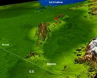 Topography Reflects Baja Quake Site's Complex Geology
Pasadena CA (JPL) Apr 07, 2010 The topography surrounding the Laguna Salada fault in the Mexican state of Baja, California, is clearly shown in this combined radar image and topographic view (above) generated with data from NASA's Shuttle Radar Topography Mission (SRTM). On April 4, 2010, a magnitude 7.2 earthquake struck along this fault about 64 kilometers (40 miles) south of the Mexico-United States border. Acc ... read more |
|
| The content herein, unless otherwise known to be public domain, are Copyright 1995-2010 - SpaceDaily. AFP and UPI Wire Stories are copyright Agence France-Presse and United Press International. ESA Portal Reports are copyright European Space Agency. All NASA sourced material is public domain. Additional copyrights may apply in whole or part to other bona fide parties. Advertising does not imply endorsement,agreement or approval of any opinions, statements or information provided by SpaceDaily on any Web page published or hosted by SpaceDaily. Privacy Statement |


 del.icio.us
 Digg
Digg Reddit
 YahooMyWeb
 Google