|
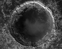
Tempe AZ (SPX) Jul 19, 2007 This image covers an impact crater roughly 4 kilometers (2.5 miles) in diameter. The subimage shows just a small segment of the crater rim (1336 x 889; 3 MB). The surface outside the crater (top) is relatively dark, while the interior wall of the crater has a lighter tone. A few dark patches on the crater wall have small dunes or ripples on their surfaces, and are likely pits filled with dark sand. The light-toned material making up the crater wall is finely layered and fractured in places. The layers may be part of a sedimentary or volcanic ash deposit that became indurated (cemented and solidified) prior to the impact that formed the crater. The impact has revealed layers that were previously buried beneath the Martian surface, similar to the craters explored by the Opportunity rover in Meridiani Planum. These craters are windows into the Martian subsurface. Just 30 kilometers (20 miles) to the east of this crater lies Mawrth Vallis, an ancient outflow channel that may have been carved by catastrophic floods. The orbiting spectrometers OMEGA (on Mars Express) and CRISM (on MRO) have detected clay minerals in layered deposits in and around Mawrth Vallis. These minerals, which require water to form, are likely present in the layered bedrock exposed in this crater wall. The crater may thus provide a glimpse into an intriguing period of Martian history, when liquid water may have been more abundant at or near the Martian surface than it is today. Related Links Arizona's HiRISE site Mars News and Information at MarsDaily.com Lunar Dreams and more
 Tucson AZ (SPX) Jun 05, 2007
Anyone connected by Internet can now see planet Mars better than at any time in history, through the eye of HiRISE, the most powerful camera ever to orbit another planet. A University of Arizona-based team that runs the High Resolution Imaging Experiment (HiRISE) camera on NASA's Mars Reconnaissance Orbiter has just released more than 1,200 Mars images to the Planetary Data System, the U.S. space agency's mission data archive. |
|
| The content herein, unless otherwise known to be public domain, are Copyright Space.TV Corporation. AFP and UPI Wire Stories are copyright Agence France-Presse and United Press International. ESA Portal Reports are copyright European Space Agency. All NASA sourced material is public domain. Additional copyrights may apply in whole or part to other bona fide parties. Advertising does not imply endorsement, agreement or approval of any opinions, statements or information provided by Space.TV Corp on any Web page published or hosted by Space.TV Corp. Privacy Statement |