|
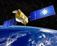
Suitland MD (SPX) May 22, 2008 A new satellite set to launch next month will monitor the rate of sea-level rise and help measure the strength of hurricanes, according to a leading NOAA scientist. At a press briefing today, Laury Miller, chief of NOAA's Laboratory for Satellite Altimetry, said NOAA will use data from the Jason-2/Ocean Surface Topography Mission (OSTM) to extend a 15-year record from two earlier altimeter missions that currently show sea level is rising at a rate of 3.2 mm/year - nearly twice as fast as the previous 100 years. "This rate, if it continues unchanged over the coming decades, will have a large impact on coastal regions, in terms of erosion and flooding," said Miller. The Jason-2/OSTM is scheduled for lift off June 15 at 1:47 a.m. from Vandenberg Air Force Base, Calif. The spacecraft is a joint, international effort between NOAA, NASA, France's Centre National d'Etudes Spatiales (CNES), and the European Organisation for the Exploitation of Meteorological Satellites (Eumetsat). Like its predecessor missions TOPEX/Poseidon and Jason-1, Jason-2/OSTM is designed to extend the climate data record by providing a long-term survey of Earth's oceans, tracking ocean circulation patterns and measuring sea-surface heights and the rate of sea-level rise. These are all key factors in understanding climate change. The satellite will use a radar altimeter instrument attached to it and fly in a low Earth orbit allowing it to monitor 95 percent of Earth's ice-free oceans every 10 days. In addition to detecting climate change factors, Jason-2/OSTM will also be used in the prediction of short-term, severe weather events, such as hurricanes and tropical storms. According to Miller, NOAA will use the altimeter measurements to monitor ocean conditions that trigger changes in the strength of tropical cyclones, as they move over the ocean towards the land. The technique involves mapping the ocean heat content - the fuel that feeds a storm's intensity - along the storm's predicted track. "Using data received in earlier altimeter missions during hurricanes with wind speeds in excess of 155 miles per hour, we've been able to reduce our intensity prediction error by an average of five percent - and in some cases as much as 20 percent," Miller said. "If we increase the accuracy of intensity predictions, we help save lives." During the Jason-2/OSTM lifespan, NOAA will work with CNES to handle the complete ground system support. This includes commanding all the satellite's maneuvers, downloading all the data the satellite captures, and distributing it to weather and climate forecasters, who are monitoring ocean-born storms and phenomena such as El Nino/La Nina and global sea-level rise. Additionally, Jason-2/OSTM will be the first, newly launched satellite in which NOAA provides ground support from its NOAA Satellite Operations Facility in Suitland, Md. The facility opened in 2007 and houses $50 million worth of high-tech equipment and controls nearly $5 billion in satellites. "NOAA is definitely up to the challenge of providing smooth, continuous operational support for this mission, which is sure to bring tangible benefits throughout the world," said Mike Mignogno, program manager for NOAA's Polar-orbiting Operational Environmental Satellites. Related Links NOAA's Polar-orbiting Operational Environmental Satellites NOAA Satellite Operations Facility Water News - Science, Technology and Politics
 Norwich, UK (SPX) May 19, 2008
As much as a third of the nitrogen entering the world's oceans from the atmosphere is man-made, according to new findings by an international team of scientists. This has significant implications for global climate change because the nitrogen causes increased marine biological activity and CO2 uptake, which in turn produces the potent greenhouse gas nitrous oxide (N20). |
|
| The content herein, unless otherwise known to be public domain, are Copyright Space.TV Corporation. AFP and UPI Wire Stories are copyright Agence France-Presse and United Press International. ESA Portal Reports are copyright European Space Agency. All NASA sourced material is public domain. Additional copyrights may apply in whole or part to other bona fide parties. Advertising does not imply endorsement, agreement or approval of any opinions, statements or information provided by Space.TV Corp on any Web page published or hosted by Space.TV Corp. Privacy Statement |