|
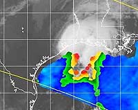
Huntsville AL (SPX) Nov 12, 2007 Meteorologists' jaws dropped as Hurricane Humberto slammed the Texas shore early morning September 13, 2007. At first just a nameless tropical depression, the storm marshaled 85 mph winds and heavy rains in the blink of an eye, demanding its identity as a category one hurricane. "It made the transition from tropical depression to hurricane within 24 hours right before landfall. It was a record breaker," says NASA atmospheric scientist Robbie Hood. Why did Humberto leap to hurricane force so quickly? More importantly, how could its rapid summoning of dangerous power have been predicted so people on shore could have been forewarned? These questions are much on the minds of hurricane forecasters. Humberto is only the latest example; two years ago, the busy hurricane season of 2005 was notable for its rapidly intensifying storms. No one knows if this is the start of a trend, but everyone would like to see improvements in forecasting storm intensity. "Forecasting intensity is one of the biggest problems we have right now with hurricanes," says Hood. But Hood and her team of researchers at NASA's Marshall Space Flight Center are making strides toward solving that problem with a new invention called HIRAD, short for Hurricane Imaging Radiometer. Computer models used to forecast hurricanes need to know wind speeds at the base of the storm. Winds close to the eye, in the eyewall, are especially important-but those winds can be the most difficult to measure. Enter HIRAD: Designed to operate from an airplane or satellite, "HIRAD will see from above through a hurricane's heaviest rains and thickest clouds to measure the intense winds at the surface of the ocean," says Hood. HIRAD measures the wind over water by sensing its froth. "Strong winds sweep and swirl across ocean waves, whipping up foamy white froth," explains Hood. "HIRAD measures microwave radiation naturally emitted by this froth; the stronger the winds, the more froth, and the more microwave radiation." HIRAD will measure a wider swath of area than traditional aircraft tools, so fewer aircraft passes will be necessary. It is smaller and lighter and requires less power than current wind measuring instruments. It has no moving parts. It's relatively inexpensive to build and has potential for satellite applications. All positives. A later version of HIRAD will be proposed to measure wind direction as well as speed. "For the best picture of what's happening inside a hurricane, you need to know both wind speed and direction. We'll look at the thickness of the foam on one side of the wave as opposed to the other. This will give us the wind direction," explains Hood. HIRAD could take its first trial run on an aircraft as early as the 2009 hurricane season and is expected to pass with "flying" colors. Then, if funding is made available, it will fly on a satellite. "When you fly an instrument on a satellite, it helps everybody on the globe," she says. "It improves forecasting around the world, for countries that don't have the ground-based radar and aircraft instruments larger countries have." Karen Stephens, HIRAD Project Manager, adds, "In the post-Katrina era, it is especially satisfying to be working on something so immediately beneficial and possibly life-saving." But first HIRAD has to prove itself and win funding to continue its development. Until then, during hurricane season, don't blink your eyes! Related Links http://science.nasa.gov/ Bringing Order To A World Of Disasters When the Earth Quakes A world of storm and tempest
 Baguio, Philippines (AFP) Nov 5, 2007
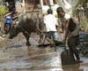
Tropical storm Peipah killed five people and left another missing after raking over the northern Philippines overnight, rescuers said Monday. |
|
| The content herein, unless otherwise known to be public domain, are Copyright Space.TV Corporation. AFP and UPI Wire Stories are copyright Agence France-Presse and United Press International. ESA Portal Reports are copyright European Space Agency. All NASA sourced material is public domain. Additional copyrights may apply in whole or part to other bona fide parties. Advertising does not imply endorsement, agreement or approval of any opinions, statements or information provided by Space.TV Corp on any Web page published or hosted by Space.TV Corp. Privacy Statement |