|
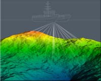
Stennis MS (AFNS) May 10, 2007 The U.S. Navy's hydrography program will enjoy an opportunity to showcase its capabilities to the world leaders in the field at two events this month. The International Hydrographic Conference, held every five years, will convene in Monaco from May 7 to 1o, and Norfolk will host the biennial U.S. Hydrographic Conference from May 15-17. Most of the time Navy hydrographers toil behind the scenes, quietly surveying waterways for military operations and in support of U.S. foreign policy to aid foreign governments, masking the discipline's importance to military operations and shipping. "Hydrography continues as the cornerstone of the U.S. Navy's oceanography program. Its unprecedented technical level is a result of a long-term commitment to the development of our people," said Rear Adm. Timothy McGee, Commander Naval Meteorology and Oceanography Command (NMOC) and Hydrographer of the Navy. "We graduated 90 Category A hydrographers into our program and our focus on the rapid insertion of the industry's latest technologies." McGee explained that hydrographers contribute to anti-submarine warfare, mine warfare, naval special warfare, navigation and fleet operations. The Naval Oceanographic Office (NAVO) and its subordinate command, the Fleet Survey Team (FST) are NMOC's operational hydrographic experts. Hydrography has become more important to the Navy in recent years as the Navy shifted its focus more to near-shore areas and shallower water. Navy hydrography also can be and has been an important tool in building new relationships with foreign governments. Like all NMOC programs, Navy hydrography is focused on the fleet and is conducted in response to fleet requirements, but sometimes those requirements go beyond the direct warfighting mission. Navy hydrographers routinely work throughout the world conducting port and harbor surveys in support of the State Department mandated Security Assistance and Theater Security Cooperation initiatives. "The international cooperation aspect of our hydrography program has given us, as a nation, opportunities to develop new international friends," McGee said. NAVO reinvigorated its program in 2000 by establishing a master's program in hydrographic science and later in 2005 with the establishment of its FST, designed to respond within 24 hours to fleet needs for surveys anywhere in the world. That reinvigoration has continued and so has the education investment. To date the Navy has sponsored 90 graduates of the master's course, which delivers an International Hydrographic Organization Category A certification to its graduates. The University of Southern Mississippi teaches and administers the master's program, which was developed with and requested by NAVO. In addition, the command sponsors and conducts a Category B certification through the International Hydrographic Management Engineering Program (IHMEP). The six-month course of study teaches students how to do hydrographic surveys and includes international students. The international aspect of IHMEP has been another part of the hydrography program that helped to build and maintain international relationships. Students from about 21 countries have participated through the years. The Navy's hydrography program also helps to establish and build those international relationships through hydrographic surveys of foreign ports and waterways, in countries that do not have the resources or the expertise to survey and chart their own. Since ports and harbors are vital to economic development and foreign trade, hydrographic surveys of those areas are welcomed as vital to economic development. Surveys can be important following natural disasters as well. Also, the Navy commitment to international assistance in hydrography includes a leadership role NMOC plays in the effort to help nations build a hydrography capability through the International Hydrographic Organization Capacity Building Council. The Capacity Building Council is a forum that gives nations a place to come for hydrographic assistance. "The fact that foreign governments invite us to do hydrographic surveys in their sovereign waters and participate in these international programs, I think, demonstrates the value of the capability as well as the level of expertise of Navy hydrographers," McGee said. The Naval Meteorology and Oceanography Command directs the Navy's meteorology, oceanography broad ocean surveillance and precise time programs and includes about 3,000 officer, enlisted and civilian personnel located worldwide. Related Links Naval Meteorology and Oceanography Water News - Science, Technology and Politics
 Vancouver (AFP) May 01, 2007
The world's oceans could rise by up to seven meters if Greenland's ice cap entirely melts because of global warming, climate scientists said Tuesday. Glaciers on Greenland, the world's most icy land mass, are now melting most quickly where they are in contact with surrounding ocean, while ice in the high centre remains intact, said Garry Clarke, a professor at the University of British Columbia in this western Canadian city. |
|
| The content herein, unless otherwise known to be public domain, are Copyright Space.TV Corporation. AFP and UPI Wire Stories are copyright Agence France-Presse and United Press International. ESA Portal Reports are copyright European Space Agency. All NASA sourced material is public domain. Additional copyrights may apply in whole or part to other bona fide parties. Advertising does not imply endorsement, agreement or approval of any opinions, statements or information provided by Space.TV Corp on any Web page published or hosted by Space.TV Corp. Privacy Statement |