|
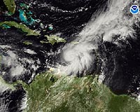
Miami (AFP) Oct 15, 2008 Hurricane Omar was churning toward the Virgin islands Wednesday gaining strength as authorities issued warnings across much of the northeastern Caribbean. With its center 380 km (235 miles) southwest of St. Croix and about 375 km (235 miles) south-southwest of San Juan, Puerto Rico, the US National Hurricane Center warned at 1500 GMT: "additional strengthening is forecast during the next 24 hours and Omar should be a Category 2 hurricane by the time it reaches the northern Leeward islands." The hurricane -- packing maximum sustained winds of near 140 kilometers (85 miles) per hour -- was moving slowly northeast toward San Juan. A hurricane warning was issued for the US Virgin Islands and islands of Vieques and Culebra, outlying isles of Puerto Rico. Authorities also issues a hurricane warning, which means hurricane conditions are expected within 24 hours, for St. Martin -- the Caribbean's main air hub after Puerto Rico -- Saba, St. Eustatius, St. Barthelemy, the British Virgin Islands, Anguilla and St. Kitts a Nevis. "Preparations to protect life and property should be rushed to completion," the NHC said. The storm was churning on its forward track about 15 km/hr (nine mph) "and this motion is expected to continue with a gradual increase in forward speed over the next day or two. "On this track Omar is forecast to move through the northern Leeward islands (just east of Puerto Rico) late (Wednesday) and early Thursday," the NHC added. "Omar is expected to produce total rainfall amounts of (10-20 cm) four to eight inches over portions of the Netherlands Antilles with maximum amounts of (30 cm) 12 inches possible. Rainfall amounts of (five-10 cm) two to four inches with maximum amounts of (15 cm) six inches are possible across extreme northwestern and north-central Venezuela and the northern Guajira peninsula. Total rainfall amounts of five-10 inches with maximum amounts up to 20 inches will be possible across Puerto Rico and the northern Leeward islands. These rains could produce life-threatening flash floods and mud slides," the NHC warned. The busy 2008 hurricane season has included devastating Hurricanes Gustav and Ike, which caused millions of dollars in damage in Haiti, Cuba and the United States. Hurricanes and tropical storms have killed hundreds across the Caribbean and Mexico, with Haiti the worst hit. Related Links Bringing Order To A World Of Disasters When the Earth Quakes A world of storm and tempest
 Miami (AFP) Oct 12, 2008
A new tropical storm formed Sunday in the eastern Atlantic Ocean, the Miami-based National Hurricane Center said. |
|
| The content herein, unless otherwise known to be public domain, are Copyright Space.TV Corporation. AFP and UPI Wire Stories are copyright Agence France-Presse and United Press International. ESA Portal Reports are copyright European Space Agency. All NASA sourced material is public domain. Additional copyrights may apply in whole or part to other bona fide parties. Advertising does not imply endorsement, agreement or approval of any opinions, statements or information provided by Space.TV Corp on any Web page published or hosted by Space.TV Corp. Privacy Statement |