| . |  |
. |
|
|
. |
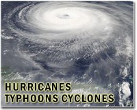
by Staff Writers Freeport, Bahamas (AFP) Aug 25, 2011
Hurricane Irene pounded the Bahamas Thursday, punishing the nation of small islands with heavy rain and powerful wind as it barrels toward the populous US east coast. Irene is a category three hurricane on the five-level Saffir-Simpson scale, and is forecast to strengthen to a category four storm with winds of 135 miles (217 kilometers) per hour by the time it reaches the US coast over the weekend. The US National Hurricane Center in Miami said the center of Irene, the first hurricane of the Atlantic storm season, was located at 0600 GMT about 165 kilometers east-southeast of Nassau, and some 1,225 kilometers (760 miles) south of Cape Hatteras, North Carolina. The storm was packing winds of 185 kilometers (115 miles) per hour, and was moving towards the north-west at 19 kilometers (12 miles) per hour. "On the forecast track, the core of the hurricane will move over the northwestern Bahamas (Thursday), and pass well offshore of the east coast of central and north Florida (late Thursday) and early Friday," the NHC said. US satellite images showed Irene churning north of Cuba's eastern Atlantic coastline. Meteorologists said its tropical force winds extended out some 255 miles (410 kilometers). In the Bahamas, a nation of 29 islands and hundreds of cays in the Atlantic ocean just outside the Caribbean, residents were preparing for the worst. "My husband already started getting the shutters together, and we're also packing to get out," said Edna Smith, whose house in Holmes Rock, Grand Bahama, was flooded in the last hurricanes in 2004 and 2005. "We're not staying there. We're probably going to a shelter." Deborah Rolle rushed to load groceries in the back of her car in Freeport after making last-minute purchases. "I'm trying to get a jump-start on things, getting everything prepared," she said. US forecasters said they expected the center of Irene to come close to Cape Hatteras, North Carolina early Saturday, then continue north over water toward the eastern edge of New York's Long Island on Sunday. Authorities began evacuating tourists from North Carolina's popular Outer Banks beach resort early Wednesday and ordered a mandatory evacuation of the Ocracoke and Hatteras barrier islands. "This could be a very large storm storm, so we are taking it very seriously," said Governor Bev Perdue. Bill Read, director of NHC, said the track remains uncertain but that "the exact center of the storm may stay close to the coast on Saturday and perhaps become a big threat to New England and Long Island." Craig Fugate, the head of the US Federal Emergency Management Agency, said emergency personnel were preparing from impact from the Carolinas to New England. "This is going to be a big storm. Just because it hits one area doesn't mean its not going to cause damage further up the coast," he said. "The most important thing for people to do right now is to listen to and follow the instructions of their local officials. If you are told to evacuate, evacuate." Up to 12 inches (30 centimeters) of rainfall were expected in parts of Bahamas and Turks and Caicos, with a "dangerous" storm surge up to 11 feet (3.3 meters) on some islands. White House spokesman Josh Earnest said that President Barack Obama was briefed Wednesday on the hurricane during his vacation in Martha's Vineyard, Massachusetts, which coincidentally could be on or near the storm path in a few days. He said officials "are looking at the very detailed logistical effort to ensure that we're going to have the proper resources pre-deployed." burs-ch/
|
. |
|
| The content herein, unless otherwise known to be public domain, are Copyright 1995-2011 - Space Media Network. AFP and UPI Wire Stories are copyright Agence France-Presse and United Press International. ESA Portal Reports are copyright European Space Agency. All NASA sourced material is public domain. Additional copyrights may apply in whole or part to other bona fide parties. Advertising does not imply endorsement,agreement or approval of any opinions, statements or information provided by Space Media Network on any Web page published or hosted by Space Media Network. Privacy Statement |

 del.icio.us
 Digg
Digg Reddit
 Google