|
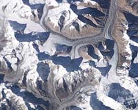
Paris, France (SPX) Mar 28, 2007 The Himalaya, the "Roof of the World", source of the seven largest rivers of Asia are, like other mountain chains, suffering the effects of global warming. To assess the extent of melting of its 33 000 km2 of glaciers, scientists have been using a process they have been pioneering for some years. Satellite-imagery derived glacier surface topographies obtained at intervals of a few years were adjusted and compared. Calculations indicated that 915 km2 of Himalayan glaciers of the test region, Spiti/Lahaul (Himachal Pradesh, India) thinned by an annual average of 0.85 m between 1999 and 2004. The technique is still experimental, but it has been validated in the Alps and could prove highly effective for watching over all the Himalayan glacier systems. However, the procedure for achieving a reliable estimate must overcome a number of sources of error and approximation inherent in satellite-based observations. The researchers started by retrieving satellite data for two periods, 2000 and 2004. A digital field model was extracted for each of them, representing the topography of a ground reference point in digital form and therefore usable in computerized processing. The earliest topography of the area studied was provided by NASA which observed 80% of the Earth's surface during the Shuttle Radar Topographic Mission of February 2000. Then, in November 2004, two 2.5 m resolution images of the same area taken at two different angles were acquired especially by the French satellite Spot5 in the framework of an ISIS (CNES) project. Comparison of these two images has helped build a field model, a Digital Elevation Model (DEM), by stereoscopic photogrammetric techniques . The DEM model reveals that NASA radar data underestimate values at high altitudes and overestimate them at lower altitudes. And the Spot satellite produces an uncertainty of +/- 25 m in the horizontal positioning of images. Moreover, as the authorities of the major Himalayan countries (India, Pakistan, China) do not permit public access to detailed topographic maps or aerial photographs of these sensitive cross-border regions, no reference is available for satellite observation error assessment and correction. It is therefore by comparing the SRTM and SPOT5 topographies using stable non-glaciated areas around glaciers that researchers have been able to adjust for the deviations and superimpose the two digital field models. These comparisons gave the bases for a map of glacier elevation (and hence thickness) variations for altitude intervals of 100 m over the period 2000-2004. The results show clear regression of the large glaciers whose terminal tongues reach the lowest levels (about 4000 m) with a thinning of 8 to 10 m below 4400 m. Such loss is 4 to 7 m between 4400 and 5000 m, passing to 2 m above 5000 m. The satellite image evaluation yields an average mass balance of -0.7 to -0.85 m/a water equivalent for the 915 km2 of glaciers surveyed, a total mass loss of 3.9 km3 of water in 5 years. In order to check these results and validate the procedure, the satellite-derived results were compared with the mass balance for the small glacier Chhota Shigri (15 km2) determined from the field measurements and surveys, performed between 2002 and 2004 by the Great Ice research unit and its Indian partners. The mass balance determined from these field data and that calculated from satellite data agree. For both evaluation methods, Chhota Shigri glacier appears to have lost an average of a little over 1 m of ice per year. These results are in line with global estimates for glacier made for the period between 2001 and 2004. The approach is therefore being extended to other areas of the Himalaya in order to gain more information on the still poorly known changes taking place in the region's glaciers, which are a water resource on which tens of millions of people depend. Related Links Institut de Recherche Pour le Developpement Learn about Climate Science at TerraDaily.com Climate Science News - Modeling, Mitigation Adaptation
 Chicago (AFP) March 26, 2007
Many of the world's climate zones will vanish entirely by 2100, or be replaced by new, previously unseen ones, if global warming continues as expected, a study released Monday said. |
|
| The content herein, unless otherwise known to be public domain, are Copyright Space.TV Corporation. AFP and UPI Wire Stories are copyright Agence France-Presse and United Press International. ESA Portal Reports are copyright European Space Agency. All NASA sourced material is public domain. Additional copyrights may apply in whole or part to other bona fide parties. Advertising does not imply endorsement, agreement or approval of any opinions, statements or information provided by Space.TV Corp on any Web page published or hosted by Space.TV Corp. Privacy Statement |