|
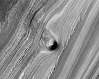
Tuscon AZ (SPX) Oct 20, 2008 An odd, solitary hill rising part-way down an eroding slope in Mars' north polar layered terrain may be the remnant of a buried impact crater, suggests a University of Arizona planetary scientist who studied the feature in a new, detailed image from the HiRISE camera onboard NASA's Mars Reconnaissance Orbiter. HiRISE, or the High Resolution Imaging Science Experiment, headed by Alfred McEwen of the Lunar and Planetary Laboratory, is based at the UA. New HiRISE images are posted weekly on the team's Web site. The north polar layered deposits are stacked up to several kilometers thick and represent one of the largest surface reservoirs of Martian water that interacts with the planet's atmosphere, said LPL's Shane Byrne. Scientists believe the deposits record orbitally driven climate changes and study them to learn how Mars climate evolved. The new HiRISE image shows an exposed 500-meter thick section (1,640 feet) of this layering, and also a 40-meter high (130-foot) conical mound sticking out of the slope. "The mound may be the remnant of a buried impact crater, which is now being exhumed," Byrne said. Impact craters would have been buried by ice as the layered deposits accumulated, with layers wrapping around the crater, Byrne said. Almost none exist on the surface of this terrain. "But in this rare case, erosion formed a trough that uncovered one of these structures. For reasons that are poorly understood right now, the ice beneath the site of the crater is more resistant to this erosion, so that as this trough formed, ice beneath the old impact site remained, forming this isolated hill." Viewing the HiRISE image at full resolution shows that the mound is made up of polygonal blocks as big as 10 meters, or 33 feet, across, he added. The blocks are covered with reddish dust, but otherwise resemble ice-rich blocks seen in other images of the north polar layered deposits. The seven new HiRISE images include another image of an impact crater where such features are rarely seen - on the north polar cap. HiRISE turned up a small crater, only about 115 meters, or 125 yards, in diameter on the surface of Planum Boreum, popularly known as the north polar cap. The dearth of craters has led scientists to suggest that either the north polar cap is only about 100,000 years old or that crater impacts into the ice disappear as the ice relaxes, just as imperfections disappear as old window glass relaxes. Color in the enhanced-color version of the Planum Boreum impact crater comes from dust and from ice of various grain sizes. Blueish ice has a larger grain size than the ice that has collected in the crater. Dust is reddish. A smooth area stretching away from the crater to the upper right of the image may be caused by winds around the crater or by fine-grained ice and frost blowing out of the crater, HiRISE scientists say. HiRISE has returned more than 8,200 gigapixel-size images of Mars' surface since the start of its science mission in November 2006. The HiRISE team so far has released a total of about 27 terabytes of data, more than all previous deep space missions combined. The Mars Reconnaissance Orbiter is managed by the Jet Propulsion Laboratory, Pasadena, Calif., for NASA's Science Mission Directorate, Washington. Lockheed Martin Space Systems of Denver built the spacecraft. The UA operates the HiRISE camera, built by Ball Aerospace and Technology Corp. of Boulder, Colo. Related Links University of Arizona Mars News and Information at MarsDaily.com Lunar Dreams and more
 Tuscon AZ (SPX) Oct 17, 2008
An odd, solitary hill rising part-way down an eroding slope in Mars' north polar layered terrain may be the remnant of a buried impact crater, suggests a University of Arizona planetary scientist who studied the feature in a new, detailed image from the HiRISE camera onboard NASA's Mars Reconnaissance Orbiter. |
|
| The content herein, unless otherwise known to be public domain, are Copyright Space.TV Corporation. AFP and UPI Wire Stories are copyright Agence France-Presse and United Press International. ESA Portal Reports are copyright European Space Agency. All NASA sourced material is public domain. Additional copyrights may apply in whole or part to other bona fide parties. Advertising does not imply endorsement, agreement or approval of any opinions, statements or information provided by Space.TV Corp on any Web page published or hosted by Space.TV Corp. Privacy Statement |