|
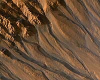
Phoenix AZ (SPX) Jan 24, 2008 Mars has an ethereal, tenuous atmosphere at less than 1 percent the surface pressure of Earth, so scientists working on The University of Arizona's High Resolution Imaging Experiment, or HiRISE, are challenged to explain the complex, wind-sculpted landforms they're now seeing in unprecedented detail. The HiRISE camera on NASA's Mars Reconnaissance Orbiter, the most powerful camera to orbit another planet, can see 20-inch-diameter features while flying at about 7,500 mph between 155 and 196 miles above the Martian surface. HiRISE is giving researchers eye-opening new views of wind-driven Mars geology. One of the main questions has been if winds on present-day Mars are strong enough to form and change geological features, or if wind-constructed formations were made in the past, perhaps when winds speeds and atmospheric pressures were higher, HiRISE team members say. "We're seeing what look like smaller sand bedforms on the tops of larger dunes, and, when we zoom in more, a third set of bedforms topping those," HiRISE co-investigator Nathan Bridges of the Jet Propulsion Laboratory in Pasadena, Calif., said. "On Earth, small bedforms can form and change on time scales as short as a day." There are two kinds of "bedforms," or wind-deposited landforms. They can be sand dunes, which are typically larger and have distinct shapes. Or they can be ripples, which is sand mixed with coarser, millimeter-sized particles. Ripples are typically smaller, more linear structures. HiRISE also shows detail in sediments deposited by winds on the lee side of rocks. Such rock "windtails" show which way the most current winds have blown, Bridges said. Such features have been seen before, but only by rovers and landers, never an orbiting camera. Researchers can now use HiRISE images to infer wind directions over the entire planet. Scientists discovered miles-long, wind-scoured ridges called "yardangs" with the first Mars orbiter, Mariner 9, in the early 1970s, Bridges said. New HiRISE images reveal surface texture and fine-scale features that are giving scientists insight on how yardangs form. "HiRISE is showing us just how interesting layers in yardangs are," Bridges said. "For example, we see one layer that appears to have rocks in it. You can actually see rocks in the layer, and if you look downslope, you can see rocks that we think have eroded out from that rocky layer above." HiRISE shows that some layers in the yardangs are made of softer materials that have been modified by wind, he added. The soft material could be volcanic ash deposits, or the dried up remnants of what once were mixtures of ice and dust, or something else. "The fact that we see layers that appear to be rocky and layers that are obviously soft says that the process that formed yardangs is no simple process but a complicated sequence of processes," Bridges said. Scientists since the 1970s Viking missions have puzzled over what appears to be dust covering Mars' 6-to-13-mile-high volcanoes. Near the volcanic summits, the air is about one one-thousandth of Earth's atmospheric pressure. "HiRISE keeps showing interesting things about terrains that I expected to be uninteresting," said HiRISE principal investigator Alfred McEwen of the UA's Lunar and Planetary Laboratory. "I was surprised by the diversity of morphology of the thick dust mantles. Instead of a uniform blanket of smooth dust, there are often intricate patterns due to the action of the wind and perhaps light cementation from atmospheric volatiles." HiRISE images show that what covers the slopes of the high Martian volcanoes are definitely dunes or ripples that appear to have an organized 'reticulate' structure possibly formed by winds blowing from multiple directions, Bridges said. "On Earth, winds blowing from many different directions form what are called 'star dunes,' and these look somewhat like those," Bridges said. "The reticulate surface looks like a network of connected wind-blown dunes and ripples. "The fact that the air pressure near the volcano tops is so low and the material is dust challenges us to understand what these features are," he said. "Perhaps the dust is clumping together and making sand-size material. But how this stuff can be blown around this low pressure is at the edge of our understanding of aeolian physics. "Possibly the bedforms on the volcanoes formed under a different Martian climate in the past, when atmospheric density was greater," Bridges said. "But I'm not sure that's the case, because you can see evidence that a lot of the mantle appears to be fairly recent." HiRISE team member Paul Geissler of the U.S. Geological Survey, in Flagstaff, Ariz., has discovered from HiRISE images that dark streaks coming from Victoria Crater are probably streaks of dark sand blown out from the crater onto the surface. Scientists had wondered if wind might have blown away lighter-colored surface material, exposing a darker underlying surface. Geissler, a member of the Mars Exploration Rover team, is comparing HiRISE images with images the Opportunity rover has taken at Victoria Crater. Bridges is lead author on the paper titled "Windy Mars: A dynamic planet as seen by the HiRISE camera" in the Geophysical Research letters in December. McEwen is among the paper's co-authors. Related Links Mars Reconnaissance Orbiter Mars News and Information at MarsDaily.com Lunar Dreams and more
 Laurel, MD (SPX) Dec 24, 2007
Scientists are getting a clearer image of mineral distribution on the surface of Mars, thanks to the Compact Reconnaissance Imaging Spectrometer for Mars (CRISM), one of six science instruments on NASA's Mars Reconnaissance Orbiter, currently circling the planet. More than 200 just-released "spectral maps" reveal the distribution of various minerals on the surface of Mars -- the first installment of the Global Mars Map, which will eventually cover the entire planet. |
|
| The content herein, unless otherwise known to be public domain, are Copyright Space.TV Corporation. AFP and UPI Wire Stories are copyright Agence France-Presse and United Press International. ESA Portal Reports are copyright European Space Agency. All NASA sourced material is public domain. Additional copyrights may apply in whole or part to other bona fide parties. Advertising does not imply endorsement, agreement or approval of any opinions, statements or information provided by Space.TV Corp on any Web page published or hosted by Space.TV Corp. Privacy Statement |