|
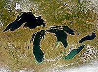
Narragansett RI (SPX) Jan 20, 2009 The water level in the Great Lakes has varied by only about two meters during the last century, helping them to play a vital role in the region's shipping, fishing, recreation and power generation industries. But new evidence by scientists from the University of Rhode Island and colleagues in the U.S. and Canada, published last month in the journal Eos, indicates that the water level in the lake system is highly sensitive to climate changes. "In the distant past, there were great fluctuations in the water level of the Great Lakes, but it was thought to have been related entirely to the advance and retreat of the glaciers," said URI geological oceanographer John King, who led the study with URI visiting scientist Michael Lewis, emeritus scientist with the Geological Survey of Canada. "But the last time lake levels fell dramatically - down to 20 meters below the basin overflow outlets - it was due to dry climate conditions." That event, which occurred between 7900 and 7500 years ago in the early Holocene period, caused the lakes to become disconnected as their overflow rivers, including the Niagara River, ran dry. "People used to say that the oceans are so big, we can dump whatever we want in them and nothing will happen," said King. "They thought of the Great Lakes in the same way, that the system is too large to be sensitive to climate variations. But now we know that to be untrue. We've demonstrated that at least once in the last 10,000 years, climate drove the lake levels down pretty substantially." Researchers had long assumed that the Great Lakes had been "hydrologically open" and connected since their formation 16,000 years ago during the retreat of the last ice sheet, but recent evidence has found this to be false. Ancient shorelines, submerged beaches, and tree stumps on the floor of some lakes indicate that the water line had been as much as 20 meters below the present lake level. "We had a multi-proxy approach to this study, and through many lines of evidence we identified this as a dry interval with a climactic cause as opposed to a glacial-related cause," King said. The climate and water levels in the Great Lakes region are determined by the interplay of three air masses: dry, cold Arctic air from the North, dry warm Pacific air from the West, and warm, moist tropical air from the Gulf of Mexico. The scientists found that during the period when lake levels receded significantly, the dry air from the Arctic and Pacific was dominant. Later, when precipitation from the tropical air mass became more frequent, the Great Lakes began to flow from one to another as they do today. King worries about the economic impact to the Great Lakes region if the present climate changes lower water levels significantly. Navigation, water usage and hydropower would be severely affected. "The climate interval that occurred back then is different from what we're going through now," King said. "It would take a pretty big change to close the basins again. But the sorts of temperatures and precipitation amounts that happened then are within the range of what is predicted for 2100. In the worst-case scenarios, a lot of things become possible. "The range of lake-level changes that are likely to happen in the next 100 years is probably larger than the range of levels observed during the last century," he added. Related Links University of Rhode Island Water News - Science, Technology and Politics
 Gaza City (AFP) Jan 17, 2009
Every day when Israel pauses its bombardment of the Gaza Strip, Palestinians launch a ground assault on the territory's public fountains to try to lay their hands on precious supplies of water. |
|
| The content herein, unless otherwise known to be public domain, are Copyright Space.TV Corporation. AFP and UPI Wire Stories are copyright Agence France-Presse and United Press International. ESA Portal Reports are copyright European Space Agency. All NASA sourced material is public domain. Additional copyrights may apply in whole or part to other bona fide parties. Advertising does not imply endorsement, agreement or approval of any opinions, statements or information provided by Space.TV Corp on any Web page published or hosted by Space.TV Corp. Privacy Statement |