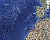
The perfect rectangle, which is around the size of Wales, was noticed on the search giant's underwater exploration tool Photo: GOOGLE EARTH
The perfect rectangle, which is around the size of Wales, was noticed on the search giant's underwater exploration tool Photo: GOOGLE EARTH |
The Daily Telegraph caused the brief flurry of excitement among Atlantis hunters by publishing Google Earth pictures on Friday of an unexplained grid on the seabed 620 miles (1,000 kilometers) off the northwestern coast of Africa.
An Atlantis expert told the paper that the grid was located at one of the possible sites of Atlantis, the legendary city described by Greek philosopher Plato.
Google, however, had another explanation.
"It's true that many amazing discoveries have been made in Google Earth -- a pristine forest in Mozambique that is home to previously unknown species, a fringing coral reef off the coast of Australia, and the remains of an Ancient Roman villa, to name just a few," Google said in a statement.
"In this case, however, what users are seeing is an artifact of the data collection process.
"Bathymetric (or seafloor terrain) data is often collected from boats using sonar to take measurements of the seafloor. The lines reflect the path of the boat as it gathers the data," Google said.
Related Links
 Greenblet MD (SPX) Feb 19, 2009
| The content herein, unless otherwise known to be public domain, are Copyright Space.TV Corporation. AFP and UPI Wire Stories are copyright Agence France-Presse and United Press International. ESA Portal Reports are copyright European Space Agency. All NASA sourced material is public domain. Additional copyrights may apply in whole or part to other bona fide parties. Advertising does not imply endorsement, agreement or approval of any opinions, statements or information provided by Space.TV Corp on any Web page published or hosted by Space.TV Corp. Privacy Statement |