 |
San Francisco (AFP) Feb 5, 2010 Google Earth mapping service is letting people use the Internet to dive into the world's oceans or see the ruin that World War II bombings rained on European cities. The Internet powerhouse on Thursday added an Ocean Showcase and WW II era aerial photographs to its free, interactive online atlas. "The historical imagery feature gives people a unique perspective on the events of the past using today's latest mapping technology," Laura Scott of Google Europe said in a blog post. "We hope that this World War II imagery will enable all of us to understand our shared history in a new way and to learn more about the impact of the war on the development of our cities." The feature includes images taken in 1943 of 35 European cities pictures and of war-battered Warsaw in 1935 and 1945. Google Earth users are able to do side-by-side comparisons of the cities then and now. "They remind us all of the devastating impact of war on the people in those cities and also the remarkable way in which urban environments are reconstructed and regenerated over time," Scott said. The Showcase adds an under-sea tour narrated by renowned National Geographic oceanographer Sylvia Earle to Google Earth. "Anyone can be a desktop (Jacques-Yves) Cousteau," Google product manager Jenifer Austin Foulkes said, referring to the famed French sea explorer. "You can pause the tour at any time to watch videos of the surrounding areas and marine animals, like the humpback whales." Photographers, naturalists, government agencies, and non-profit groups have contributed countless photos and videos to an Explore the Ocean layer of Google Earth launched a year ago. The service has grown to include tours of Monterey Bay Aquarium, sunken ships, and prize surfing locales.
Share This Article With Planet Earth
Related Links Earth Observation News - Suppiliers, Technology and Application
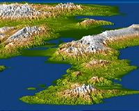 Fault Responsible For Haiti Quake Slices Island's Topography
Washington DC (SPX) Jan 18, 2010 A magnitude 7.0 earthquake occurred on January 12, 2010, at Port-au-Prince, Haiti, with major impact to the region and its citizens. This perspective view of the pre-quake topography of the area clearly shows the fault that is apparently responsible for the earthquake as a prominent linear landform immediately adjacent to the city. Elevation is color coded from dark green at low elevations ... read more |
|
| The content herein, unless otherwise known to be public domain, are Copyright 1995-2010 - SpaceDaily. AFP and UPI Wire Stories are copyright Agence France-Presse and United Press International. ESA Portal Reports are copyright European Space Agency. All NASA sourced material is public domain. Additional copyrights may apply in whole or part to other bona fide parties. Advertising does not imply endorsement,agreement or approval of any opinions, statements or information provided by SpaceDaily on any Web page published or hosted by SpaceDaily. Privacy Statement |


 del.icio.us
 Digg
Digg Reddit
 YahooMyWeb
 Google