|
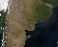
Buenos Aires (AFP) Jul 24, 2007 Argentina's tax authorities are using satellite images generated on the Internet by Google Earth to track down fraud, local media said Friday. According to Buenos Aires province tax official Santiago Montoya, images of properties from the sky can help square the actual size of properties with that declared by taxpayers to make sure the proper amount of taxes is being paid, the reports said. The online Google Earth service, which assembles detailed satellite pictures together with maps so that users can view specific locations and buildings, is also used by the Buenos Aires authorities to check if taxpayers may have expanded their homes in ways that would increase their value for taxation. Montoya said he is waging "a real war" on fiscal deficits, and has already taken several steps to reduce the widespread tax fraud in Argentina.
Source: Agence France-Presse Related Links Military Space News at SpaceWar.com
 San Diego CA (SPX) Jul 19, 2007
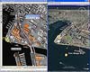
A new version of BAE Systems' image analysis and mapping software enables analysts to evaluate and share intelligence data more effectively by integrating with Google Earth and the ESRI geodatabase. SOCET GXP v2.3 interacts with Google Earth in real time for quick, 3D color visualization and gives geospatial context to objects of interest, resulting in enhanced intelligence for mission planning. |
|
| The content herein, unless otherwise known to be public domain, are Copyright Space.TV Corporation. AFP and UPI Wire Stories are copyright Agence France-Presse and United Press International. ESA Portal Reports are copyright European Space Agency. All NASA sourced material is public domain. Additional copyrights may apply in whole or part to other bona fide parties. Advertising does not imply endorsement, agreement or approval of any opinions, statements or information provided by Space.TV Corp on any Web page published or hosted by Space.TV Corp. Privacy Statement |