|
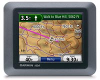
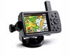
Olathe KS (SPX) Jul 25, 2008 Garmin International has announced a new series of personal navigators that combine cutting edge navigation features with outdoor recreation navigation capabilities. With one touch, the nuvi 500 transitions between driving, bicycling, boating or walking mode, while boasting sought-after features such as routing capabilities, improved mapping and water-proof hardware. "This multi-mode nuvi is the ultimate device for those seeking portable navigation in the car and in the great outdoors," said Dan Bartel, Garmin's vice president of worldwide sales. "This product allows us to combine features from several of our most popular automotive and outdoor navigators into one compact unit. From weekend trips to the lake, to a hike around the trail, nuvi 500 is ideal for people seeking automotive and recreational navigation in one dynamic device." Drive, hike, bike or boat with this portable and rugged unit + the nuvi 500 is pre-loaded with both road maps and U.S. topographic maps. For use in and out of the car, simply touch the usage mode indicator located at the top of the home screen to change between driving, bicycling, boating or walking mode. This series comes standard with a compass page, track log and a removable, rechargeable battery for extended outdoor use. With one tap of the screen, users can also see their exact location with Garmin's "Where Am I?" feature. In addition, with Garmin Connect Photos, users can choose from millions of geo-located photos provided by Google's Panoramio photo sharing community to provide photo navigation by land or water. When loaded with optional BlueChart g2 Vision, and Inland Lake Vision marine cartography, the nuvi 500 series is great on the water, providing detailed chart-specific information, spot soundings, intertidal zones, wrecks, port plans, restricted areas and more. For a scenic road trip, the nuvi 500 series comes preloaded with the Historic Route 66 map guide developed by MAD MAPS. This route spans from Chicago to Los Angeles, while highlighting specific points of interest associated with Route 66 along the way. The nuvi 500 comes preloaded with detailed street and topographic mapping for the lower 48 U.S. states, Hawaii and Puerto Rico. The nuvi 550 boasts comprehensive street map coverage of the U.S. and Canada. When either model is used with an optional receiver, users can receive important updated information from Traffic Message Channel or MSN Direct. The dynamic content from the MSN Direct network includes traffic conditions, fuel prices, weather reports, movie listings, headline news, stock updates and local events. A scooter mount will come standard in select European markets and sold as an optional accessory elsewhere. Related Links Garmin International GPS Applications, Technology and Suppliers
 San Diego CA (SPX) Jul 16, 2008
Researchers at San Diego State University have developed a new concept for improving MEMS accelerometer tunability. This method can increase wide-band tunability with ranges much larger than current practice, a significant improvement from the previously accepted 5-10%. |
|
| The content herein, unless otherwise known to be public domain, are Copyright Space.TV Corporation. AFP and UPI Wire Stories are copyright Agence France-Presse and United Press International. ESA Portal Reports are copyright European Space Agency. All NASA sourced material is public domain. Additional copyrights may apply in whole or part to other bona fide parties. Advertising does not imply endorsement, agreement or approval of any opinions, statements or information provided by Space.TV Corp on any Web page published or hosted by Space.TV Corp. Privacy Statement |