 |
Olathe KS (SPX) Mar 11, 2011 Garmin International has announced the G1000H, an all-glass avionics system designed specifically for the VFR Part 27 helicopter market. The G1000H provides important flight data - flight instrumentation, navigation, communication, weather, terrain, traffic, identification, and diagnostics and maintenance computer - and presents it digitally to the pilot on large, high-resolution displays. "The G1000H is a highly flexible and scalable solution designed to fit a broad range of helicopter manufacturers panels and configurations," said Gary Kelley, Garmin's vice president of marketing. "It brings an unprecedented level of safety, simplicity and situational awareness within reach of new helicopter buyers." Leveraging the best features from its fixed-wing G1000 counterpart, the G1000H seamlessly integrates control and presentation of virtually all flight data, sensor and instrument functions in one comprehensive "big picture" package. The G1000H includes features like single or dual integrated solid-state attitude and heading reference systems (AHRS) that can align while in motion, including in-flight dynamic restarts and handle highly dynamic flight maneuvers; full reversionary capabilities allowing all flight-critical data to transfer seamlessly to a single display; integrated digital audio control system; and integrated Mode S transponder that interfaces to Garmin's TIS capable transponders and ADS-B transceivers. The physical architecture of the G1000H uses modern data-bus technology that reduces wire count and overall weight and simplifies installation and maintenance. Line-replaceable units (LRUs), which have been designed to withstand helicopter vibration levels, are integrated with sensors throughout the aircraft and transfer data seamlessly from these sensors to the PFD/MFD to deliver real-time information to the pilot. The robust G1000H also has numerous optional features that are also available to manufacturers: + HSVT displays an "out-the-window" view of the surroundings, regardless of the weather conditions. This synthetic vision seamlessly blends information about the rotorcraft's position with topographic databases to create and display real-time 3D images. Land, water and sky are clearly differentiated with shading and textures that are similar to the topographical colors found on the MFD moving map. HSVT alerts pilots of potential ground hazards by displaying terrain and obstacles which pose a threat to the aircraft. (optional) + HTAWS provides graphical and audible alerts of potential terrain and obstacle conflicts along the flight path. Garmin's HTAWS includes forward looking terrain avoidance (FLTA) capability with visual and aural advisories to keep pilots informed of hazardous terrain and obstacles. (optional) + GDL 69AH enables the display of graphical XM WX weather including NEXRAD, METARs, TAFs, TFRs, winds aloft, echo tops, precipitation type at the surface, lightning strikes, storm-cell data, AIRMETs, and SIGMETs. It also supports digital-quality audio via XM radio. (optional) + GTS series traffic systems offers TAS or TCAS I capability and combines active and passive surveillance data to pinpoint specific traffic threats. (optional) + GSR 56H Iridium datalink and GDL 59H data logger and Wi-Fi datalink are independent systems that offer features like worldwide weather, voice communication, text messaging and data communication (optional). + GMA 350H digital audio panel with voice recognition, 3D spatial audio processing, advanced auto squelch, three COM support, night vision compatibles green annunciation and backlighting, and new split-COM modes (1/3 and 2/3), and ambient noise based volume adjustment so that pilots' workload is decreased while increasing their situational awareness.
Share This Article With Planet Earth
Related Links Garmin's complete line of helicopter products GPS Applications, Technology and Suppliers
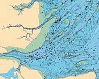 New Marine And Coastal Geospatial Data Available
Leicester, UK (SPX) Mar 11, 2011 Astrium GEO-Information Services has introduced new marine and coastal geospatial data that is now downloadable from its www.geostore.com store. The new data includes the Admiralty Raster Charts, and a new generation of vector data known as Marine Themes that is based on information sourced from the UK Hydrographic Office. Easily accessed online, the new marine and coastal data will be par ... read more |
|
| The content herein, unless otherwise known to be public domain, are Copyright 1995-2010 - SpaceDaily. AFP and UPI Wire Stories are copyright Agence France-Presse and United Press International. ESA Portal Reports are copyright European Space Agency. All NASA sourced material is public domain. Additional copyrights may apply in whole or part to other bona fide parties. Advertising does not imply endorsement,agreement or approval of any opinions, statements or information provided by SpaceDaily on any Web page published or hosted by SpaceDaily. Privacy Statement |


 del.icio.us
 Digg
Digg Reddit
 YahooMyWeb
 Google