|
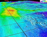
Tucson AZ (SPX) Nov 18, 2008 An international team of scientists who analyzed data from the Gamma Ray Spectrometer onboard NASA's Mars Odyssey reports new evidence for the controversial idea that oceans once covered about a third of ancient Mars. "We compared Gamma Ray Spectrometer data on potassium, thorium and iron above and below a shoreline believed to mark an ancient ocean that covered a third of Mars' surface, and an inner shoreline believed to mark a younger, smaller ocean," said University of Arizona planetary geologist James M. Dohm, who led the international investigation. "Our investigation posed the question, Might we see a greater concentration of these elements within the ancient shorelines because water and rock containing the elements moved from the highlands to the lowlands, where they eventually ponded as large water bodies?" Dohm said. Mars Odyssey's GRS, or Gamma Ray Spectrometer, led by William Boynton of UA's Lunar and Planetary Laboratory, has the unique ability to detect elements buried as much as 1/3 meter, or 13 inches, below the surface by the gamma rays they emit. That capability led to GRS' dramatic 2002 discovery of water-ice near the surface throughout much of high-latitude Mars. Results from Mars Odyssey and other spacecraft suggest that past watery conditions likely leached, transported and concentrated such elements as potassium, thorium and iron, Dohm said. "The regions below and above the two shoreline boundaries are like cookie cutouts that can be compared to the regions above the boundaries, as well as the total region." The younger, inner shoreline is evidence that an ocean about 10 times the size of the Mediterranean Sea, or about the size of North America, existed on the northern plains of Mars a few billion years ago. The larger, more ancient shoreline that covered a third of Mars held an ocean about 20 times the size of the Mediterranean, the researchers estimate. The potassium-thorium-iron enriched areas occur below the older and younger paleo-ocean boundaries with respect to the entire region, they said. The scientists used data from Mars Global Surveyor's laser altimeter for topographic maps of the regions in their study. They are reporting their findings in the article, "GRS Evidence and the Possibility of Paleo-oceans on Mars." The article will be published in a special edition of Planetary and Space Science, which stems from a June 2007 workshop on Mars and its Earth analogs held in Trento, Italy. UA Regents' Professor Victor Baker and Boynton, and other scientists from the United States, Italy, Spain, South Korea and Canada are co-authors. Scientific debate on the possible existence of ancient Martian oceans marked by shorelines was sparked by several studies almost 20 years ago. One such study, by Baker and colleagues at the UA Lunar and Planetary Laboratory, proposed that a few billion years ago, erupting magma unleashed floods far greater than Brazil's Amazon River. The floods ponded in the northern lowlands of Mars, forming seas and lakes that triggered relatively warmer and wetter conditions that lasted tens of thousands of years. Scientists are driven to understand how and when water existed on Mars because water is critical to life. Spacecraft images going back to Mariner 9 in the early 1970s and the Viking orbiters and landers later in the 1970s showed widespread evidence for a watery past for Mars. Images and other information from a flotilla of U.S. and European Mars orbiters have sharpened the details in the past decade, they added. Results from Mars Global Surveyor, Mars Odyssey, Mars Express and Mars Reconnaissance Orbiter highlight a water-and-ice-sculpted Martian landscape. Scientists studying spacecraft images have a hard time confirming "shoreline" landforms, the researchers said, because Mars shorelines would look different from Earth's shorelines. Earth's coastal shorelines are largely a direct result of powerful tides caused by gravitational interaction between Earth and the moon, but Mars lacks a sizable moon. Another difference is that lakes or seas on Mars could have formed largely from giant debris flows and liquefied sediments. Still another difference is that Mars oceans may have been ice-covered, which would prevent wave action. "The GRS adds key information to the long-standing oceans-on-Mars controversy," Dohm said. "But the debate is likely to continue well into the future, perhaps even when scientists can finally walk the Martian surface with instruments in hand, with a network of smarter spaceborne, airborne and ground-based robotic systems in their midst." Related Links University of Arizona Mars News and Information at MarsDaily.com Lunar Dreams and more
 Moffett Field CA (SPX) Nov 14, 2008
Detecting water underground does not require a magical stick. Neutrons reflecting out of the soil can indicate the presence of water or ice. A novel instrument that can detect those neutrons is planned for NASA's next rover mission to Mars. |
|
| The content herein, unless otherwise known to be public domain, are Copyright Space.TV Corporation. AFP and UPI Wire Stories are copyright Agence France-Presse and United Press International. ESA Portal Reports are copyright European Space Agency. All NASA sourced material is public domain. Additional copyrights may apply in whole or part to other bona fide parties. Advertising does not imply endorsement, agreement or approval of any opinions, statements or information provided by Space.TV Corp on any Web page published or hosted by Space.TV Corp. Privacy Statement |