 |
Paris, France (ESA) Jun 30, 2010 The first global gravity model based on GOCE satellite data has been presented at ESA's Living Planet Symposium. ESA launched GOCE in March 2009 to map Earth's gravity with unprecedented accuracy and resolution. The model, based on only two months of data, from November and December 2009, shows the excellent capability of the satellite to map tiny variations in Earth's gravity. "GOCE is delivering where it promised: in the fine spatial scales," GOCE Mission Manager Rune Floberghagen said. "We have already been able to identify significant improvements in the high-resolution 'geoid', and the gravity model will improve as more data become available." The geoid is the shape of an imaginary global ocean dictated by gravity in the absence of tides and currents. It is a crucial reference for accurately measuring ocean circulation, sea-level change and ice dynamics - all affected by climate change. Chairman of the GOCE Mission Advisory Group and Head of the Institute for Astronomical and Physical Geodesy at the Technische Universitat Munchen, Prof. Reiner Rummel, said: "The computed global gravity field looks very promising. We can already see that important new information will be obtained for large areas of South America, Africa, Himalaya, South-East Asia and Antarctica." "Over continents, and in particular in regions poorly mapped with terrestrial or airborne techniques, we can already conclude that GOCE is changing our understanding of the gravity field," Dr Floberghagen added. "Over major parts of the oceans, the situation is even clearer, as the marine gravity field at high spatial resolution is for the first time independently determined by an instrument of such quality." New GOCE models are already yielding a wealth of new information that is useful for many domains of geosciences. GOCE's final gravity map and geoid will be instrumental in advancing science and applications in a broad range of disciplines, ranging from geodesy, geophysics and surveying to oceanography and sea-level research. "With each two-month cycle of data, the gravity model will become more detailed and accurate. I am convinced that the data will be of great interest to various disciplines of Earth sciences," Prof. Rummel said.
Excellent technical achievement In order to achieve its very challenging mission objectives, the satellite was designed to orbit at a very low altitude, where the gravitational variations are stronger closer to Earth. Since mid-September 2009, GOCE has been in its gravity-mapping orbit at a mere 254.9 km mean altitude - the lowest orbit sustained over a long period by any Earth observation satellite. The residual air at this low altitude causes the orbit of a standard satellite to decay very rapidly. GOCE, however, continuously nullifies the drag in real time by firing an ion thruster using xenon gas. It ensures the gravity sensors are flying as though they are in pure freefall, so they pick up only gravity readings and not the disturbing effects from other forces. To obtain clean gravity readings, there can be no disturbances from moving parts, so the entire satellite is a single extremely sensitive measuring device. "The gravity measuring system is functioning extremely well. The system is actively compensating for the effects of atmospheric drag and delivering a continuous set of clean gravity readings," Dr Floberghagen said. "This in itself is an excellent technical achievement. GOCE has proven to be a nearly perfect satellite for measuring gravity from space." In May, ESA made available the first set of gravity gradients and 'high-low satellite-to-satellite tracking'. These data are available to scientific and non-commercial users - and much more will come in the following months.
Share This Article With Planet Earth
Related Links GOCE at ESA The Physics of Time and Space
 XMM-Newton Line Detection Provides New Tool To Probe Extreme Gravity
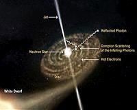
Paris, France (ESA) Jun 22, 2010 A long-sought-after emission line of oxygen, carrying the imprint of strong gravitational fields, has been discovered in the XMM-Newton spectrum of an exotic binary system composed of two stellar remnants, a neutron star and a white dwarf. Astronomers can use this line to probe extreme gravity effects in the region close to the surface of a neutron star. Stellar remnants are the last evolu ... read more |
|
| The content herein, unless otherwise known to be public domain, are Copyright 1995-2010 - SpaceDaily. AFP and UPI Wire Stories are copyright Agence France-Presse and United Press International. ESA Portal Reports are copyright European Space Agency. All NASA sourced material is public domain. Additional copyrights may apply in whole or part to other bona fide parties. Advertising does not imply endorsement,agreement or approval of any opinions, statements or information provided by SpaceDaily on any Web page published or hosted by SpaceDaily. Privacy Statement |


 del.icio.us
 Digg
Digg Reddit
 YahooMyWeb
 Google