|
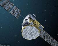
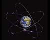
Paris, France (ESA) May 08, 2008 Following a successful launch on 27 April, GIOVE-B began transmitting navigation signals today. This is a truly historic step for satellite navigation since GIOVE-B is now, for the first time, transmitting the GPS-Galileo common signal using a specific optimised waveform, MBOC (multiplexed binary offset carrier), in accordance with the agreement drawn up in July 2007 by the EU and the US for their respective systems, Galileo and the future GPS III. These GIOVE-B signals, locked on-board to a highly stable Passive Hydrogen Maser clock, will provide higher accuracy in challenging environments where multipath and interference are present, and deeper penetration for indoor navigation. It demonstrates that Galileo and GPS are truly compatible and interoperable and that positioning services will benefit all users worldwide. "Now with GIOVE-B broadcasting its highly accurate signal in space we have a true representation of what Galileo will offer to provide the most advanced satellite positioning services, while ensuring compatibility and interoperability with GPS", said Galileo Project Manager, Javier Benedicto. After launch, early orbit operations and platform commissioning, GIOVE-B's navigation payload was switched on and signal transmission commenced on 7 May and the quality of these signals is now being checked. Several facilities are involved in this process, including the GIOVE-B Control Centre at Telespazio's facilities in Fucino, Italy, the Galileo Processing Centre at ESA's European Space Research and Technology Centre (ESTEC), in the Netherlands, the ESA ground station at Redu, Belgium, and the Rutherford Appleton Laboratory (RAL) Chilbolton Observatory in the United Kingdom. Chilbolton's 25-metre antenna makes it possible to analyse the characteristics of GIOVE-B signals with great accuracy and verify that they conform to the Galileo system's design specification. Each time the satellite is visible from Redu and Chilbolton, the large antennas are activated and track the satellite. GIOVE-B is orbiting at an altitude of 23 173 kilometres, making a complete journey around the Earth in 14 hours and 3 minutes. The quality of the signals transmitted by GIOVE-B will have an important influence on the accuracy of the positioning information that will be provided by the user receivers on the ground. Onboard, GIOVE-B carries a passive hydrogen maser atomic clock, which is expected to deliver unprecedented stability performance. The signal quality can be affected by the environment of the satellite in its orbit and by the propagation path of the signals travelling from space to ground. Additionally, the satellite signals must not create interference with services operating in adjacent frequency bands, and this is also being checked. Galileo teams within ESA and industry have the means to observe and record the spectrum of the signals transmitted by GIOVE-B in real time. Several measurements are performed relating to transmitted signal power, centre frequency and bandwidth, as well as the format of the navigation signals generated on board. This allows the analysis of the satellite transmissions in the three frequency bands reserved for it. The GIOVE-B mission also represents an opportunity for validating in-orbit critical satellite technologies, characterising the Medium Earth Orbit (MEO) radiation environment, and to test a key element of the future Galileo system - the user receivers. Related Links European GNSS Supervisory Authority Galileo at EU GPS Applications, Technology and Suppliers
 Strasbourg (AFP) April 23, 2008
Europe's long-delayed Galileo satellite navigation system passed its final legal hurdle on Wednesday after the European Parliament gave the flag-ship project its green light. |
|
| The content herein, unless otherwise known to be public domain, are Copyright Space.TV Corporation. AFP and UPI Wire Stories are copyright Agence France-Presse and United Press International. ESA Portal Reports are copyright European Space Agency. All NASA sourced material is public domain. Additional copyrights may apply in whole or part to other bona fide parties. Advertising does not imply endorsement, agreement or approval of any opinions, statements or information provided by Space.TV Corp on any Web page published or hosted by Space.TV Corp. Privacy Statement |