|
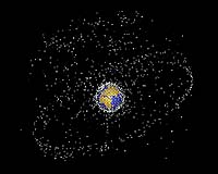
Air Force Space Command Public Affairs Peterson AFB CO (SPX) Mar 04, 2008 "Near-Earth objects can travel up to 17,000 miles per hour, so a collision with a launching or orbiting satellite or with a manned space craft, could be catastrophic," said Terje Turner of AFSPC Air, Space and Nuclear Operations directorate. "Every space launch requires that these objects be tracked closely in order to avoid accidental collisions." Air Force Space Command is always busy with its mission of delivering space and missile capabilities to America and its warfighting commands. Within that spectrum, one of its most important jobs is to know where about 17,000 man-made space objects are within the 60- to 20,000-mile band above the Earth. Mr. Turner described the two categories of objects. "First there are catalogued objects. These are objects whose origin is certain -- about 12,000. Analysis objects, those we can identify but are uncertain of their origins, are the second class. There are roughly 6,000 of these," he said. The objects range in size from about four inches in diameter -- baseball-size -- to 90 by 150 by 200 feet and 520,000 tons, the International Space Station. What are these space objects? Roughly seven percent of them are operational satellites. About 15 percent are rocket bodies, and about 78 percent are fragments of rocket bodies and inactive satellites. For instance, the oldest piece of space debris is a sphere, six inches in diameter, launched in March 1958. The Space Surveillance Network, a consortium of Air Force and Army ground-based and space-based radars and optical sensors located at about 20 sites around the world, has been tracking objects in orbit since 1957. Why is it important to know where all these objects are located? Mr. Turner likens the Space Surveillance Network to a space neighborhood watch. "We provide tracking information to a number of organizations in the Department of Defense and the civilian communities," said Mr. Turner. "We have a pilot program we are working on called the Commercial and Foreign Entities Program, where we are working out how to tell satellite owners if one of their satellites might be in danger of a collision with another object. "We inform them, and it is up to them to determine what action to take," he said. "That early warning is important, because it gives these folks the time to make better decisions." How do they do it? Looking at the space shuttle, for example, computer models determine the flight path of the shuttle based on information provided by the SSN. There is an imaginary box drawn around the shuttle, measuring six by six by 25 miles. If any of the objects intersect this imaginary box along the pre-determined flight path during the proposed flight time, NASA can then order changes to the flight plan, or launch time, to remove the danger. Douglas Wood of CNN reported in 2005 that "NASA has changed the shuttle's flight path 12 times since the Air Force Space Command's Space Control Center began performing its analysis in 1981. The center also works for the International Space station," he added. "NASA has moved the ISS six times based on SCC analysis." If it sounds like there is a huge layer of material orbiting around the Earth, requiring launching craft to dodge and scurry around them, this is not the case. "Only a small amount of debris exists where the shuttle orbits, and the likelihood of a 'significant collision' between a piece of debris and the shuttle is extremely remote," Mr. Wood said. Even though the numbers cited here sound rather large, in the 60- to 20,000-mile band in which the SSN tracks, there are usually only about three or four objects in an area roughly equal in size to the airspace of the continental United States. While manned craft can be directed around orbiting debris, the debris pieces themselves are simply moving in an orbit defined by the physics of the events causing them to become scrap in the first place. Even though they are scattered through an area that is defined by vertical and horizontal parameters, pieces have collided, creating even more debris to be monitored. Not all the items remain in space. It seems that the rule is 'what goes up, might come down.' Some objects re-enter the Earth's atmosphere and either burn up completely as they pass through the upper levels, or if the pieces are large enough, they impact the surface. Mr. Turner says that the SSN tracks these pieces, watching the orbits denigrate, often for weeks and months before re-entry and, early on in this process, his organization shares the information with the appropriate agencies. This information is particularly valuable when it looks like some of the debris might survive re-entry, which happened recently with the U.S. Satellite, SN 193. "With every launch we have the capacity for more space debris to accumulate," Mr. Nelson said. "That is why the efforts of the SSN are so important." Related Links Space Tourism, Space Transport and Space Exploration News
 Paris, France (ESA) Feb 28, 2008
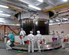
Jules Verne, the first Automated Transfer Vehicle, has been encapsulated in its huge fairing on top of the Ariane 5 launcher. With a total mass of about 19 360 kg, Jules Verne is the largest payload ever launched by Ariane 5. This historical mission with the first European space supplier for the ISS is scheduled for a night time launch on 8 March at 04.23 UT. |
|
| The content herein, unless otherwise known to be public domain, are Copyright Space.TV Corporation. AFP and UPI Wire Stories are copyright Agence France-Presse and United Press International. ESA Portal Reports are copyright European Space Agency. All NASA sourced material is public domain. Additional copyrights may apply in whole or part to other bona fide parties. Advertising does not imply endorsement, agreement or approval of any opinions, statements or information provided by Space.TV Corp on any Web page published or hosted by Space.TV Corp. Privacy Statement |