 |
by Dr. Ray Williamson, Executive Director - Secure World Foundation Washington DC (SPX) Jul 14, 2010 The influence of Earth remote sensing satellites in disaster management can be greatly enhanced over the next decade, becoming a far more powerful tool than today to help mitigate the effects of natural and human-made calamities. A future look into the unrealized potential of remotely sensed data for pre-, during, and post-disaster scenarios was detailed by Dr. Ray Williamson, Executive Director of Secure World Foundation during a Disasters Roundtable, held July 8 by The National Academies in Washington, D.C. The roundtable - From Reality 2010 to Vision 2020: Translating Remotely Sensed Data to Assets, Exposure, Damage, and Losses - brought together leading experts from academia, the government and private sector to focus on needed improvements in disaster response and recovery. In his keynote address, Williamson outlined both positive trends and potential impediments regarding use of spaceborne systems and other technologies.
Response and recovery Williamson also noted that satellite telecommunications can be used more effectively to deliver information to response and recovery teams throughout the recuperation process. "There are many possible improvements in disaster response and recovery on the horizon," Williamson said. "Response and recovery teams could soon use the latest in smart phones and other related devices to deliver information back to coordinating organizations," he added, to assure safety of life of first responders and to serve afflicted populations. This is an example of what is becoming known as community remote sensing, or cloud computing.
Empowered by technology "It is also a world where local environmental groups concerned about degradation of local waterways are empowered by technology and their own ingenuity to collect on-the-spot data on water quality and changing shorelines and incorporate them into regional information collected from space platforms," Williamson said. "However, too often the benefits of geospatial data and tools do not reach broadly enough, especially in developing countries," Williamson said. "Failures often stem from uncoordinated policies at different levels of government, as well as restrictive data policies. Progress will require a lot more attention to removing these institutional and social impediments that now exist in using remote sensing for human benefit." To help counter these issues, more scientific and technical education and training is needed. "Most important, citizens need to become involved in their own future by using tools developed for them and also by them," Williamson advised.
Internet tools "My wider vision is a world where individuals and community groups have routine access to satellite and aerial data and use community remote sensing methods to improve their own quality of life," Williamson concluded.
Share This Article With Planet Earth
Related Links Secure World Foundation Bringing Order To A World Of Disasters A world of storm and tempest When the Earth Quakes
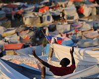 Haitians mark poignant six-month quake anniversary
Port-Au-Prince (AFP) July 12, 2010 Haitians marked a sad anniversary Monday, mourning the hundreds of thousands killed six months ago in a massive earthquake and eyeing a precarious future amid the slow trickle of aid. In the ruins of the presidential palace toppled by the January 12 quake that measured 7.0 in magnitude, international supporters joined Haitian President Rene Preval and other leaders in a poignant remembrance ... read more |
|
| The content herein, unless otherwise known to be public domain, are Copyright 1995-2010 - SpaceDaily. AFP and UPI Wire Stories are copyright Agence France-Presse and United Press International. ESA Portal Reports are copyright European Space Agency. All NASA sourced material is public domain. Additional copyrights may apply in whole or part to other bona fide parties. Advertising does not imply endorsement,agreement or approval of any opinions, statements or information provided by SpaceDaily on any Web page published or hosted by SpaceDaily. Privacy Statement |


 del.icio.us
 Digg
Digg Reddit
 YahooMyWeb
 Google