Space Industry and Business News  
Craters In Caloris

The fact that both of these craters, which show different material characteristics, are located within Caloris basin provides information about the variety and complexity of processes that have shaped Mercury's surface.
by Staff Writers
Laurel MD (SPX) Mar 04, 2008
As MESSENGER sped by Mercury on January 14, 2008, the Narrow Angle Camera (NAC) of the Mercury Dual Imaging System (MDIS) captured this image, which includes the edge of the planet against the blackness of space. Much of the foreground shows a portion of Caloris basin, one of the largest impact basins in the solar system. The large crater in the bottom middle of this image has a diameter of about 70 kilometers (40 miles).

Caloris basin is an area of particular interest to the MESSENGER science team, since understanding its formation can lead to insights about the nature of large impacts in the early solar system and the results of these catastrophic events. In a false-color image of Mercury Caloris basin is visible in the northern hemisphere of the planet as a large, light-colored, roughly circular feature; the floor of the basin may have some differences in its composition compared with the darker surrounding surfaces.

The two large craters shown in the released image are each surrounded by a "halo" of dark material, like the craters shown in our release of February 21. The smaller of the two craters has an unusual pattern of bright, highly reflective material on its floor. The fact that both of these craters, which show different material characteristics, are located within Caloris basin provides information about the variety and complexity of processes that have shaped Mercury's surface.

Related Links
MESSENGER first flyby
News Flash at Mercury
Mars News and Information at MarsDaily.com
Lunar Dreams and more


Memory Foam Mattress Review
Newsletters :: SpaceDaily :: SpaceWar :: TerraDaily :: Energy Daily
XML Feeds :: Space News :: Earth News :: War News :: Solar Energy News


MESSENGER: Craters With Dark Halos On Mercury
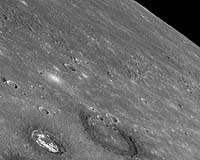
Laurel MD (SPX) Feb 25, 2008
As MESSENGER flew by Mercury on January 14, 2008, the Narrow Angle Camera (NAC) of the Mercury Dual Imaging System (MDIS) captured this view. Two of the larger craters in this image appear to have darkened crater rims and partial "halos" of dark material immediately surrounding the craters.


  • Google stock price sinks on Internet ad-slump fears
  • HP And Qualcomm To Deliver Options For Worldwide Internet Access
  • Google's Android debuts in Barcelona
  • Nokia says to launch touch-screen phone in late '08

  • ILS Announces Contract To Launch Two Sirius Satellite Radio Spacecraft On Proton Breeze M
  • Arianespace Prepares For Its First Two Ariane 5 Missions Of 2008
  • Russia's Proton-M To Orbit Another UAE Telecoms Satellite
  • ILS Proton To Launch S2M Satellite For Mobile TV Service In Middle East And North Africa

  • Environmentalists climb on Heathrow jet in airport protest: officials
  • NASA opens a rotary wing research project
  • All-star line-up at first Singapore Airshow
  • Military Aircraft To Perform Aviation Safety Research

  • Orbital Awarded Contract For System F6 Satellite Program By DARPA
  • Lockheed Martin Completes Rigorous Test Of First Advanced Military Communications Satellite
  • Northrop Grumman And Harris Demonstrate Airborne Networking
  • EADS DS Delivers Army Command And Control Information System To Franco-German Brigade

  • Boeing Satellites Reach 2500 Years Of Accumulated On Orbit Services
  • Satellite Debris Analysis Indicates Hydrazine Tank Hit
  • Darkest material developed in lab
  • NASA And Northrop Grumman Partner To Measure The Immeasurable

  • NASA Names John Shannon New Space Shuttle Manager
  • Michael Larkin Appointed Executive Vice President Of Orbital's Satellite Business Unit
  • Boeing Integrated Defense Systems Looks To Future With Leadership Changes
  • Raytheon Space and Airborne Systems Names Carey VP For ISR Systems

  • Falcon Investigates Pollution From The Dakar Metropolis Into Desert Dust Layers
  • NASA Extends Mission For Ball Aerospace-Built ICESat
  • CIRA Scientist Among Authors Of Book Celebrating 50 Years Of Earth Observations From Space
  • Indonesia To Develop New EO Satellite

  • Antenna Software Launches AMP Location At Gartner Wireless And Mobile Summit
  • SkyBitz And StarTrak Systems Launch SkyBitz Reefer Control Solution
  • TomTom Reveals Revolutionary IQ Routes Technology On New TomTom GO Series
  • Trimble Introduces Flexible GNSS Mapping And GIS Solution

  • The content herein, unless otherwise known to be public domain, are Copyright Space.TV Corporation. AFP and UPI Wire Stories are copyright Agence France-Presse and United Press International. ESA Portal Reports are copyright European Space Agency. All NASA sourced material is public domain. Additional copyrights may apply in whole or part to other bona fide parties. Advertising does not imply endorsement, agreement or approval of any opinions, statements or information provided by Space.TV Corp on any Web page published or hosted by Space.TV Corp. Privacy Statement