 |
Paris (AFP) May 09, 2007 Powerful computer models that simulate ocean circulation -- a key factor in the global-warming equation -- will have to be fine-tuned after scientists discovered a massive eddy in the current that sweeps around Antarctica. The oceans play a vital role in global warming, for the surface layers of the sea absorb heat and carbon dioxide (CO2) from the atmosphere. It is essential to know what happens to this warmth and CO2. By knowing the ocean currents, scientists can get an idea as to how swiftly surface warmth will start to heat up lower levels and whether the CO2, absorbed by algae, is sequestered at the ocean bottom or in contrast churned back up to the surface. The new discovery focuses on the Antarctic Circumpolar Current (ACC), which picks up and cools water that descends from warmer latitudes in the Atlantic, Indian and Pacific oceans. Scientists led by Alberto Naveira Garabato of the University of Southampton's National Oceanography Centre, southern England, hit on the idea of using a natural plume of helium, disgorged from a submarine volcano in the East Pacific, as a tracer for the ACC. They found an extraordinary mixing of the ACC in the Southwestern Atlantic at the Scotia Sea, a triangular-shaped area between Tierra del Fuego and the Antarctic peninsula. The Scotia Sea is notorious for the storms that lash its surface, but what surprised the researchers was the violent twisting of the layers underneath. The eddy cuts across isopycnals -- layers of the sea that are of different densities -- and effectively acts as a "short circuit" in the ACC. The apparent cause is the rough topography of the sea bed. The study appears on Thursday in Nature, the weekly British science journal.
Source: Agence France-Presse Related Links Epidemics on Earth - Bird Flu, HIV/AIDS, Ebola
 Moss Landing CA (SPX) Apr 03, 2007
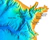
Near the town of Moss Landing, California, midway between Santa Cruz to the north and Monterey to the south, the Salinas River empties lazily out into the Pacific Ocean. What makes this otherwise unremarkable juncture unique is that it lies at the mouth of Monterey Canyon, one of the longest and deepest underwater canyons in continental North America. |
|
| The content herein, unless otherwise known to be public domain, are Copyright Space.TV Corporation. AFP and UPI Wire Stories are copyright Agence France-Presse and United Press International. ESA Portal Reports are copyright European Space Agency. All NASA sourced material is public domain. Additional copyrights may apply in whole or part to other bona fide parties. Advertising does not imply endorsement, agreement or approval of any opinions, statements or information provided by Space.TV Corp on any Web page published or hosted by Space.TV Corp. Privacy Statement |

