Space Industry and Business News  
China Claims First Artificial Snowfall In Drought-Hit Tibet

Recent Chinese meteorological studies have found precipitation is declining and temperatures rising on the Tibetan plateau, a vital hydrological region because it is the source of many major rivers that flow through China and other countries.
by Staff Writers
Beijing (AFP) April 18, 2007
China has successfully created artificial snow in the mountainous region of Tibet, raising hopes of a man-made solution to drought and melting glaciers there, state media reported on Wednesday.

The artificial snowfall was engineered on April 10 at an altitude of 4,500 metres (14,700 feet) in Nagqu country in northern Tibet, Xinhua news agency said, quoting the local meteorological station.

"The first artificial snowfall proves it's possible to change the weather through human efforts on the world's highest plateau," said Yu Zhongshui, an engineer with the meteorological station.

The snowfall measured one centimetre (0.4 inches) deep.

"To launch artificial precipitation can help alleviate drought on the grassland in northern Tibet," said Yu.

Xinhua did not give details of the method used but chemicals such as silver iodide spread by aircraft or rockets are commonly used in cloud seeding to increase rainfall in arid regions.

Recent Chinese meteorological studies have found precipitation is declining and temperatures rising on the Tibetan plateau, a vital hydrological region because it is the source of many major rivers that flow through China and other countries.

The studies have noted the region's glaciers also were receding at a rapid clip.

Source: Agence France-Presse

Related Links
It's A White Out at TerraDaily.com


Memory Foam Mattress Review
Newsletters :: SpaceDaily :: SpaceWar :: TerraDaily :: Energy Daily
XML Feeds :: Space News :: Earth News :: War News :: Solar Energy News


Snowmelt Monitored In The Baltic Sea Watershed Region In Near Real Time
Helsinki, Finland (ESA) Apr 09, 2007
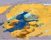
As spring melt of winter snow is underway in the Baltic Sea watershed region, satellites are monitoring and mapping the snow melting process to help local authorities manage water supplies and predict and prepare for floods. Remote sensing is the only technique capable of providing a comprehensive view over such a large area.


  • All Of Russia Will Have Internet And Phone Access
  • Wildblue High-Speed Internet Via Satellite Triples Capacity With New Satellite
  • Publish, Perish Attitudes Make Profs Balk At Online Publication
  • World Getting Ready To Change The Light Bulb

  • Russia Puts 16 Foreign Satellites Into Orbit
  • Indian Space Agency Set For First Commercial Launch Of Foreign Satellite
  • Russia To Launch Four US Satellites In May
  • PSLV-C8 To Be Launched On April 23

  • Nondestructive Testing Keeps Bagram Aircraft Flying
  • New FAA Oceanic Air Traffic System Designed By Lockheed Martin Fully Operational
  • NASA Seeks New Research Proposals
  • Germans Urged To Give Foreign Travel A Rest To Curb Global Warming

  • Raytheon To Supply Canada With Enhanced Position Location Reporting System Terminals
  • Intelsat To Test Internet Routing In Space For The US Military
  • Northrop Grumman And LockMart Team Up For Integrated Air And Missile Defense Battle Command
  • Harris Donates OS/COMET For Use In FalconSAT Program

  • Colombia Launches First Satellite
  • A New Generation Of Space Tethers
  • Rolls-Royce Selects Bristol University For Composites Research
  • Tests Demonstrate Functionality Of Next Generation Processor Router For TSAT

  • Townsend To Lead Ball Aerospace Exploration Systems In Huntsville
  • NASA Nobel Prize Recipient To Lead Chief Scientist Office
  • Kathryn Kynard Plays Key Role In Ares I Upper Stage Engine Development
  • William Shernit Joins Intelsat General As President and CEO

  • Scientists Meet To Review Envisat Results After Five Years Of Operations
  • US Uses Landsat Satellite Data To Fight Hunger And Poverty
  • NOAA And NASA Restore Climate Sensor To Upcoming NPP Satellite
  • High-Resolution Images Herald New Era In Earth Sciences

  • Northrop Grumman Team OCX Bids On The GPS Next Generation Control Segment Contract
  • China Launches Compass Navigation Satellite
  • GPS Significantly Impacted By Powerful Solar Radio Burst
  • Russia To Expand Glonass Satellite Group By Year End

  • The content herein, unless otherwise known to be public domain, are Copyright Space.TV Corporation. AFP and UPI Wire Stories are copyright Agence France-Presse and United Press International. ESA Portal Reports are copyright European Space Agency. All NASA sourced material is public domain. Additional copyrights may apply in whole or part to other bona fide parties. Advertising does not imply endorsement, agreement or approval of any opinions, statements or information provided by Space.TV Corp on any Web page published or hosted by Space.TV Corp. Privacy Statement