|
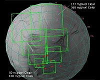
Pasadena CA (SPX) Oct 30, 2008 Following on the heels of the spectacularly successful 'skeet shoot' maneuver on August 11, Cassini will use the same technique to obtain high resolution images of the south polar region of Enceladus as it flies within 171 km of the icy moon on October 31. Earlier this month on October 9, Cassini came within 25 km (15 miles) of the surface and then flew through the icy plumes emanating from the moon's south pole at an altitude of 185 km (116 miles). This time, as on August 11, ISS and the rest of the optical remote sensing (ORS) instruments will be aimed at the surface during closest approach in order to capture high-resolution views of active vent regions. Cassini will follow essentially the same trajectory (green line at right) as it did during all previous flybys in 2008, approaching from the north, passing behind the nightside of Enceladus, and receding with a view of the south polar terrain before the moon slips into Saturn's shadow for approx. 2.5 hours. Closest approach occurs at 17:14:51 UTC on October 31, 2008, approximately 171 km (107 miles) above a point just below the equator on the leading hemisphere (latitude 28 S, longitude 93 W). The detailed schedule of events of flyby activities is described below. Flyby encounter observations of Enceladus begin on October 31 at 8:35:51 UTC, 8.5 hours prior to closest approach when Cassini begins a 30-minute long turn to aim its ORS instruments at the icy moon. For the next three hours, Cassini's Ultraviolet Imaging Spectrometer (UVIS) will be "prime", meaning that the spacecraft pointing will be optimized to meet the scientific objectives of that instrument. The other ORS instruments (ISS, Composite Infrared Spectrograph CIRS, and Visual and Infrared Mapping Spectrometer VIMS) are all aligned so even though they do not control spacecraft pointing at this time, for the most part they will be pointed at Enceladus and making measurements simultaneously as "ride along" observations. UVIS will determine the distribution of volatiles in the vicinity of Enceladus, looking for any changes in their quantity or composition as a result of plume activity. These maps of the space around Enceladus will search for the signature of oxygen, a product of the dissociation of the water molecules coming from Enceladus' plume. At the end of this observation, Enceladus is approx. 290,000 km away, and Cassini is directly above latitude 63 N, longitude 46 W, staring at northern portions of the sunlit trailing hemisphere. ISS will obtain multispectral images of the northern cratered terrains at a phase angle of 110 degrees and resolution of 2 km/pixel (1.25 miles/pixel) in the Narrow Angle Camera (NAC). At 12:14:51 UTC, 5 hours prior to closest approach, VIMS will be obtaining spectra of the northern cratered terrains during an hour-long observation. During previous flybys, VIMS detected carbon dioxide, hydrogen peroxide, and light organics near the south pole. This observation will characterize the surface composition of the northern, cratered terrains. In addition VIMS can also measure the crystallinity, temperature, and size of particles on Enceladus' surface. At the end of this hour-long observation, Enceladus will be 235,000 km above latitude 63 N, longitude 56 W. All of the other ORS instruments will ride along, and ISS will obtain a single clear filter (CL1 CL2) image as well as images at polarization angles of 0, 60, and 120 degrees in the ultraviolet (UV3) and green (GRN) filters at a phase angle of 109 degrees and resolution of 1.5 km/pixel (0.9 miles/pixel). Following the VIMS observation, at 13:14:51, four hours prior to closest approach, CIRS will observe the northern cratered terrains for nearly 3 hours. ISS will obtain four clear filter images in its Wide Angle Camera (WAC) at various times throughout this observation when CIRS is using its long-wavelength focal plane (FP1) which places Enceladus out of the NAC field of view. Near the end of this observation the spacecraft will be pointed such that the sunlit portion of Enceladus' northern trailing hemisphere nearly fills the entire field of view of the NAC. ISS will acquire several images in the clear (CL1 CL2), UV3, GRN, red (RED), blue (BL1), and near-infrared (IR1 and IR3) filters in addition to images at polarization angles of 0, 60, and 120 degrees in the UV3, GRN, and methane (MT2) filters. The clear filter image at 530 meters/pixel (580 yds/pixel) of the cratered terrains on the trailing side of the north pole will be useful for limb topography and satellite shape measurements and can also be used with similar views acquired during previous flybys to create stereo images and digital terrain maps. At 16:04:51 UTC, one hour and ten minutes prior to closest approach, VIMS will be prime once again. ISS ride along and obtain images in the CLR, UV3, GRN, IR1 and IR3 filters at a resolution of 420 meters/pixel (460 yds/pixel). In these ride-along observations, the spacecraft is directly above the nightside of Enceladus, yet sunlit portions of the northern cratered terrains will fall within the ISS NAC field of view. Next, Cassini will turn to a staging attitude to set up the second 'skeet shoot' of its Equinox Mission. During the initial phase of the high-resolution imaging sequence, or skeet shoot, the spacecraft will be so close to Enceladus and moving so quickly that it is not physically possible for it to target and track with stability any specific geologic feature on the icy satellite surface. A special spacecraft maneuver was implemented for this and the August 11 flyby so that Cassini's ORS platform will at first point ahead of Enceladus while the spacecraft is spun at its fastest speed in the direction that the moon moves across the sky. When Enceladus' apparent motion eventually overtakes the spacecraft spin and passes in front of the ISS cameras, the relative motion of the camera aimpoint across the surface of Enceladus will be briefly matched well enough so that the ISS NAC will be able to obtain ten high-resolution snap-shots of selected geological features. The groundtrack of the camera's pointing has been selected so that it will cut across two tiger stripes, or sulci, prominent rifts through which jets of water vapor and ice particles are known to be erupting. The swath was chosen to pass over three particular segments of the tiger stripes that are known to be local hot spots and which are sites of previously observed eruptions. The entire skeet shoot maneuver begins as the spacecraft view passes across the terminator from the night side of Enceladus to the illuminated dayside, with closest approach taking place 171 km (107 miles) over latitude 28 S longitude 93 W at 17:14:51 UTC. At 17:15:09 UTC, a mere 18 seconds after closest approach, the shutters on both the ISS NAC and WAC will open to acquire a couple of "shots in the dark" to optimize the timing of the following skeet shoot images. At 17:15:42 UTC, ISS will acquire the first of the skeet shoot targets, a WAC image centered on the terminator at a resolution of 64 meters/pixel (70 yds/pixel). The first fully daylit footprint, with a spatial resolution of 10 meters/pixel (33 feet/pixel) in the NAC, will be placed 33 seconds later on the bright, icy grooved terrain that lies between the tiger stripes known as Baghdad and Damascus Sulci. The subsequent two footprints (with spatial resolutions of 13 and 17 meters/pixel (43 and 56 feet/pixel), respectively) will be placed nearby, with the third footprint centered on Baghdad sulcus. The fourth NAC image will be binned 2x2, so the resolution will be 40 meters/pixel (44 yds/pixel) in this 512x512 pixel image; the footprint will nearly overlap that of the previous image. As the groundtrack continues to traverse the surface, ISS will obtain a 23 meters/pixel (25 yds/pixel) image just to the south of Damascus Sulcus. Following two images at resolutions 26 and 30 meters/pixel (28 and 33 yds/pixel) north of Damascus Sulcus, ISS has placed the eighth NAC footprint off the groundtrack so that CIRS will be able to measure temperatures along the rift floor of Damascus using its mid-infrared focal plane (FP4) instrument. Here the resolution is 33 meters/pixel (36 yds/pixel) resolution of the same area. The ninth and tenth NAC footprints, at 37 and 40 meters/pixel (40 and 44 yds/pixel), will be of an eruption site on Baghdad Sulcus, oriented so that CIRS will be able to measure temperatures along the rift floor. Once the skeet shoot sequence is complete, Cassini will again track Enceladus and acquire an 8-footprint mosaic of the South polar region in the CLR, UV3, GRN, IR1 and IR3 filters at resolutions from 40 to 177 meters/pixel (44 to 194 yds/pixel) in the clear filter from 100 to 368 meters/pixel (109 to 402 yds/pixel) in the color filters. In addition, in the fourth and fifth panels, images at polarization angles of 0, 60, and 120 degrees will be obtained in the GRN filter. Dwell times at each panel will be at least 2 minutes in order to let VIMS, riding along on this observation, integrate long enough to get high signal-to-noise. VIMS will obtain multispectral data that will be used to measure spatial variations in the size of ice grains on the surface in unprecedented detail. At 17:44:51 UTC, UVIS will be the prime instrument for the next 20 minutes during which it will map the ultraviolet surface albedo of the south polar region, scanning along the terminator, moving northward along the trailing hemisphere. UVIS will measure differences in the ultraviolet albedo of the surface in order to characterize the grain sizes of particles near the tiger stripes and those far from them, in an effort to distinguish between new and old terrain. ISS, CIRS, and VIMS will all ride along. CIRS will use this opportunity to fill in a gap in its high-resolution mapping of the south polar region with its near-infrared focal plane (FP3) instrument. ISS will obtain five clear filter images at resolutions ranging from 250 meters/pixel (276 yds/pixel) to 290 meters/pixel (318 yds/pixel) at a phase angle of 73 degrees. At this point, Cassini will be speeding away from Enceladus at 17.5 km/sec (11 miles/sec, or nearly 39,500 mph). At 18:04:30 UTC, Enceladus slips behind Saturn's shadow for an eclipse lasting just over 2.5 hours. CIRS takes over as the prime instrument for another 3-hour long observation, beginning at 18:04:51 UTC. CIRS begins this observation time with a stare at the south pole with its far-infrared focal plane instrument (FP1) sensitive to wavelengths between 17 and 1000 microns, to constrain total heat flow from the region. CIRS will then scan the entire south polar terrain using its mid-infrared focal plane FP3, sensitive to wavelengths between 9 and 17 microns, to fill in gaps in the spatial coverage acquired on previous flybys and look for any temporal variability in thermal emission from the region. CIRS can measure heat flow at higher spatial resolution and contrast using its FP3 instrument than it can with FP1. CIRS will then stare at the south pole with FP3 so ISS and the other ORS instruments can acquire data without interference from spacecraft motion across the disk of Enceladus. ISS will ride along, as it has done in the previous three close flybys this year, obtaining observations of the south polar terrain while Enceladus is in eclipse, some of which support CIRS science objectives by providing valuable pointing information. The resolution in the NAC will be approx. 650 meters/pixel (693 yds/pixel) and the phase angle remains 73 degrees. Following the stare, CIRS will acquire global scans of the southern hemisphere using FP3 and FP4. Then, as during previous flybys, in an effort to study the physical properties of Enceladus' surface, CIRS will observe the warming of the surface with FP1 as the moon egresses from Saturn's shadow. By the end of this 3-hour long observation, the resolution will have decreased to 1.4 km/pixel (0.9 miles/pixel). At 21:14:51 UTC, VIMS will be the prime instrument for an hour-long observation in which it will stare at the south pole of Enceladus. The rest of the ORS instruments will ride along, and ISS will acquire multispectral images in several filters including images at polarization angles of 0, 60, and 120 degrees in the UV3, GRN, and MT2 filters. The resolution will be 1.7 km/pixel (1 mile/pixel) and the phase angle is 74 degrees. The spacecraft is directly below latitude 63 S, longitude 330 W. Cassini's Radio Science Subsystem (RSS) will make gravity measurements of Enceladus on the "wings" of this flyby, twelve hours prior to and ten hours following closest approach. RSS will refine knowledge of Encleadus' mass and hopefully place constraints on its internal structure. Later in its Equinox Mission on Rev 130 on April 28, 2010, Cassini will conduct an Enceladus flyby which is dedicated to RSS measurements of Enceladus gravity and its internal mass distribution Although the spacecraft orientation is optimized for the ORS instruments during this flyby, the fields and particles instruments will be riding along as well. The Ion and Neutral Mass Spectrometer (INMS) obtained unexpectedly high signals during the August 11 flyby when the spacecraft pointing was optimized for the ORS and not the fields and particles instruments, so useful data may be acquired by INMS during this flyby as well. The Radio and Plasma Wave Science (RPWS) instrument will measure the thermal plasma environment, measure plasma waves associated with the magnetospheric interaction with Enceladus, and measure the flux of micron-sized particles associated with Enceladus and its plumes. This is Cassini's final Enceladus flyby of 2008. The next close flyby of Enceladus takes place in Rev 120, just over a year from now on November 2, 2009 when the spacecraft will fly deeper into the plumes than ever before and the emphasis will not be on high resolution surface imaging. However, high resolution images of the plumes will be acquired. Closest approach during the early November 2009 flyby will be at an altitude of only 100 km directly above the south pole, following the pink line in the trajectory graphic above. Related Links Cassini Explore The Ring World of Saturn and her moons Jupiter and its Moons The million outer planets of a star called Sol News Flash at Mercury
 Moffett Field CA (SPX) Oct 09, 2008
NASA's Cassini spacecraft is scheduled to fly within 16 miles of Saturn's moon Enceladus on Oct. 9 and measure molecules in its space environment that could give insight into the history of the solar system. |
|
| The content herein, unless otherwise known to be public domain, are Copyright Space.TV Corporation. AFP and UPI Wire Stories are copyright Agence France-Presse and United Press International. ESA Portal Reports are copyright European Space Agency. All NASA sourced material is public domain. Additional copyrights may apply in whole or part to other bona fide parties. Advertising does not imply endorsement, agreement or approval of any opinions, statements or information provided by Space.TV Corp on any Web page published or hosted by Space.TV Corp. Privacy Statement |