|
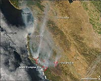
Washington DC (SPX) Jul 03, 2008 Numerous wildfires continue to burn out of control throughout California. Many of these fires were ignited in late June by dry lighting and made worse by parched conditions and a lack of rainfall, fire officials report. NASA's Aqua satellite captured this image of several of the blazes as it passed over California on June 30, 2008. This image specifically shows the fires burning in the area south of Monterey, some of the state's largest according to fire officials. Active fires are outlined in red. Smoke can also be seen billowing north up the California coastline. According to news reports, about 364,600 acres, or almost 570 square miles, of land throughout the state have already burned, and most of the blazes have not yet been contained. Skies in the north were mostly cloudy when NASA's Aqua satellite passed over California on June 30, 2008, but the Moderate Resolution Imaging Spectroradiometer (MODIS) sensor was able to get this cloud-free shot of Southern California showing fires burning south of Monterey. Places where the sensor detected actively burning fires are outlined in red. Smoke spreads north up the coast. The two fires pictured are among the largest of scores of fires burning in the state. According to the July 1 report from the National Interagency Fire Center, the Indians Fire was 81,378 acres and 95 percent contained; the Basin Complex Fire was 39,906 acres and 3 percent contained. The high-resolution image provided above is at MODIS' maximum spatial resolution (level of detail) of 250 meters per pixel. The MODIS Rapid Response Team provides twice-daily images of Northern and Southern California in additional resolutions and formats, including an infrared-enhanced version that highlights the presence of burned ground. Related Links Forest and Wild Fires - News, Science and Technology
 Washington DC (SPX) Jun 16, 2008
As the summer fire season heats up, NASA aircraft are set to follow the trail of smoke plumes from some of Earth's northernmost forest fires, examining their contribution to arctic pollution and implications for climate change. |
|
| The content herein, unless otherwise known to be public domain, are Copyright Space.TV Corporation. AFP and UPI Wire Stories are copyright Agence France-Presse and United Press International. ESA Portal Reports are copyright European Space Agency. All NASA sourced material is public domain. Additional copyrights may apply in whole or part to other bona fide parties. Advertising does not imply endorsement, agreement or approval of any opinions, statements or information provided by Space.TV Corp on any Web page published or hosted by Space.TV Corp. Privacy Statement |