|
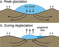
Columbus OH (SPX) Dec 30, 2008 As ice melts away from Antarctica, parts of the continental bedrock are rising in response - and other parts are sinking, scientists have discovered. The finding will give much needed perspective to satellite instruments that measure ice loss on the continent, and help improve estimates of future sea level rise. "Our preliminary results show that we can dramatically improve our estimates of whether Antarctica is gaining or losing ice," said Terry Wilson, associate professor of earth sciences at Ohio State University. Wilson reported the research in a press conference Monday, December 15, 2008 at the American Geophysical Union meeting in San Francisco. These results come from a trio of global positioning system (GPS) sensor networks on the continent. Wilson leads POLENET, a growing network of GPS trackers and seismic sensors implanted in the bedrock beneath the West Antarctic Ice Sheet (WAIS). POLENET is reoccupying sites previously measured by the West Antarctic GPS Network (WAGN) and the Transantarctic Mountains Deformation (TAMDEF) network. In separate sessions at the meeting, Michael Bevis, Ohio Eminent Scholar in geodyamics and professor of earth sciences at Ohio State, presented results from WAGN, while doctoral student Michael Willis presented results from TAMDEF. Taken together, the three projects are yielding the best view yet of what's happening under the ice. When satellites measure the height of the WAIS, scientists calculate ice thickness by subtracting the height of the earth beneath it. They must take into account whether the bedrock is rising or falling. Ice weighs down the bedrock, but as the ice melts, the earth slowly rebounds. Gravity measurements, too, rely on knowledge of the bedrock. As the crust under Antarctica rises, the mantle layer below it flows in to fill the gap. That mass change must be subtracted from Gravity Recovery and Climate Experiment (GRACE) satellite measurements in order to isolate gravity changes caused by the thickening or thinning of the ice. Before POLENET and its more spatially limited predecessors, scientists had few direct measurements of the bedrock. They had to rely on computer models, which now appear to be incorrect. "When you compare how fast the earth is rising, and where, to the models of where ice is being lost and how much is lost - they don't match," Wilson said. "There are places where the models predict no crustal uplift, where we see several millimeters of uplift per year. We even have evidence of other places sinking, which is not predicted by any of the models." A few millimeters may sound like a small change, but it's actually quite large, she explained. Crustal uplift in parts of North America is measured on the scale of millimeters per year. POLENET's GPS sensors measure how much the crust is rising or falling, while the seismic sensors measure the stiffness of the bedrock - a key factor for predicting how much the bedrock will rise in the future. "We're pinning down both parts of this problem, which will improve the correction made to the satellite data, which will in turn improve what we know about whether we're gaining ice or losing ice," Wilson said. Better estimates of sea level rise can then follow. POLENET scientists have been implanting sensors in Antarctica since December 2007. The network will be complete in 2010 and will record data into 2012. Selected sites may remain as a permanent Antarctic observational network. Scientists around the world can access POLENET data online, and schools can access educational resources as part of the International Polar Year. Ohio State's POLENET partners in the United States are Pennsylvania State University, the University of Texas at Austin, New Mexico Tech, Washington University, the Jet Propulsion Laboratory, and the University of Memphis. A host of international partners are part of the effort as well. Related Links Ohio State University Beyond the Ice Age
 Paris, France (ESA) Dec 04, 2008
New rifts have developed on the Wilkins Ice Shelf that could lead to the opening of the ice bridge that has been preventing the ice shelf from disintegrating and breaking away from the Antarctic Peninsula. |
|
| The content herein, unless otherwise known to be public domain, are Copyright Space.TV Corporation. AFP and UPI Wire Stories are copyright Agence France-Presse and United Press International. ESA Portal Reports are copyright European Space Agency. All NASA sourced material is public domain. Additional copyrights may apply in whole or part to other bona fide parties. Advertising does not imply endorsement, agreement or approval of any opinions, statements or information provided by Space.TV Corp on any Web page published or hosted by Space.TV Corp. Privacy Statement |