|
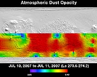
Tempe AZ (SPX) Jul 13, 2007 Scientists at Arizona State University's Mars Space Flight Center are using the Thermal Emission Imaging System (THEMIS) on NASA's Mars Odyssey orbiter to monitor a large dust storm on the Red Planet. The instrument, a multi-wavelength camera sensitive to five visible wavelengths and 10 infrared ones, is providing Mars scientists and spacecraft controllers with global maps that track how much atmospheric dust is obscuring the planet. The dust storm, which erupted during the last week of June 2007, is affecting operations for all five spacecraft operating at Mars. The fleet includes two NASA rovers on the ground (Spirit and Opportunity), plus three orbiters, two of which belong to NASA (Mars Odyssey and Mars Reconnaissance Orbiter) and one to the European Space Agency (Mars Express). Beginning in Mars' heavily cratered southern highlands, the dust storm took roughly a week to grow large enough to encircle the planet. Dust has now drifted into the northern hemisphere as well. "This is the favorable time of the Martian year for dust storms," says Joshua Bandfield, research associate at the Mars Space Flight Facility. The facility is part of the School of Earth and Space Exploration in ASU's College of Liberal Arts and Sciences. "It's summer in the southern hemisphere," he says, "That's when Mars lies closest to the sun and solar heating is greatest." Bandfield adds, "We can watch weather fronts spreading and kicking up dust in a big way." He explains that as winds sweep dust into the atmosphere, the atmosphere becomes warmer. This adds to the storm's power, helping it to pick up more dust. But the process has a built-in limitation, he says. "When the dust becomes thick enough, it reflects more sunlight from the atmosphere, allowing the air near the surface to cool." As seen from orbit, the dust storm has the effect of veiling surface features - or even concealing them completely, which hasn't happened yet in this event. "This storm isn't as big or severe as the one in 2001," Bandfield says. "THEMIS and other orbiters can still see the surface, despite the continuing dust activity." From the ground, the dust in the air has cut the amount of sunlight reaching the rovers' solar panels and reducing their electrical power. "If you were standing there, you'd see the sky looking tawny with haze," explains Bandfield. "The sun would appear as a sharp-edged disk, but the light level would be noticeably lower than what you would see under a totally clear sky." Luckily, say scientists, summer is a time when the rovers can best survive under reduced power. If the storm had struck during local winter, the rovers might not get enough power during the day to stay alive through the cold Martian night. How long will this storm last" No one knows for sure, but Bandfield notes its effects won't disappear as quickly as the storm erupted. "Mars," he says, "will remain dusty for at least a couple months more." Related Links School of Earth and Space Exploration at ASU Mars News and Information at MarsDaily.com Lunar Dreams and more
 Tempe, AZ (SPX) Jun 08, 2007
The Thermal Emission Imaging System (THEMIS) aboard NASA's Mars Odyssey orbiter marked a milestone May 4. An image from THEMIS showing Martian lava flows and wind streaks mingling with impact craters, became the 1,200th "Image of the Day" posted online. The Mars Space Flight Facility at ASU operates the site, which is updated every weekday with images and data from THEMIS. The first "Image of the Day" was posted March 27, 2002. |
|
| The content herein, unless otherwise known to be public domain, are Copyright Space.TV Corporation. AFP and UPI Wire Stories are copyright Agence France-Presse and United Press International. ESA Portal Reports are copyright European Space Agency. All NASA sourced material is public domain. Additional copyrights may apply in whole or part to other bona fide parties. Advertising does not imply endorsement, agreement or approval of any opinions, statements or information provided by Space.TV Corp on any Web page published or hosted by Space.TV Corp. Privacy Statement |