|
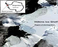
Boulder CO (SPX) Mar 26, 2008 Satellite imagery from the University of Colorado at Boulder's National Snow and Ice Data Center shows a portion of Antarctica's massive Wilkins Ice Shelf has begun to collapse because of rapid climate change in a fast-warming region of the continent. While the area of collapse involves 160 square miles at present, a large part of the 5,000-square-mile Wilkins Ice Shelf is now supported only by a narrow strip of ice between two islands, said CU-Boulder's Ted Scambos, lead scientist at NSIDC. "If there is a little bit more retreat, this last 'ice buttress' could collapse and we'd likely lose about half the total ice shelf area in the next few years." In the past 50 years, the western Antarctic Peninsula has experienced the biggest temperature increase on Earth, rising by 0.9 degree F per decade. "We believe the Wilkins has been in place for at least a few hundred years, but warm air and exposure to ocean waves are causing a breakup," said Scambos, who first spotted the disintegration activity in March. Satellite images indicate the Wilkins began its collapse on Feb. 28. Data revealed that a large iceberg, measuring 25.5 by 1.5 miles, fell away from the ice shelf's southwestern front, triggering a runaway disintegration of 220 square miles of the shelf interior. The Wilkins Ice Shelf is a broad sheet of permanent floating ice on the southwest Antarctic Peninsula roughly 1,000 miles south of South America. The edge of the shelf crumbled into the sky-blue pattern of exposed deep glacial ice that has become characteristic of climate-induced ice shelf breakups such as the Larsen B ice shelf breakup in 2002, said Scambos. A narrow beam of intact ice about 3.7 miles wide was protecting the remaining shelf from further breakup as of March 23. Scientists track ice shelves and study collapses carefully because some of them hold back glaciers, which if unleashed, can accelerate and raise sea level, Scambos said. "The Wilkins disintegration won't raise sea level because it already floats in the ocean, and few glaciers flow into it. However, the collapse underscores that the Wilkins region has experienced an intense melt season. Regional sea ice has all but vanished, leaving the ice shelf exposed to the action of waves." With Antarctica's summer melt season drawing to a close, scientists do not expect the Wilkins to further disintegrate in the next several months. "This unusual show is over for this season," Scambos said. "But come January, we'll be watching to see if the Wilkins continues to fall apart." After images from NASA's Moderate Resolution Imaging Spectroradiometer, or MODIS, and data from the ICESat satellite showed that a portion of the ice shelf was in a state of collapse in March, Scambos alerted colleagues around the world. The British Antarctic Survey flew over the shelf, collecting video footage and other observations. BAS glaciologist David Vaughan, who said the ice shelf is supported by a single strip of ice strung between two islands, said the Wilkins is the largest ice shelf on West Antarctica yet to be threatened. "This shelf is hanging by a thread." Associate Professor Cheng-Chien Liu at Taiwan's National Cheng-Kung University used high-resolution color satellite images of the area from Taiwan's Formosat-2 satellite operated by the National Space Organization to analyze the activity. "It looks as if something is slicing the ice shelf piece by piece on an incredible scale, kilometers long but only a few hundred meters in width," Cheng-Chien said. In addition, Andres Rivera and Gino Cassasa at the Laboratory for Glaciology and Climate Change at the Center of Scientific Study in Chile acquired images of the Wilkins from the ASTER instrument aboard NASA's Terra satellite. The combined efforts have begun to provide observational data that will improve scientific understanding of the mechanisms behind ice shelf collapse, Scambos said. "The Wilkins is an example of an event we don't see very often, but it's a key process in being able to predict how sea level will change in the future." The Wilkins is one of a string of ice shelves that have collapsed in the West Antarctic Peninsula in the past 30 years. The Larsen B became the most well-known of these, disappearing in just over 30 days in 2002. The Prince Gustav Channel, Larsen Inlet, Larsen A, Wordie, Muller and Jones ice shelf collapses also underscore the unprecedented warming in this region of Antarctica, said Scambos. Related Links University of Colorado at Boulder Beyond the Ice Age
 Bozeman MT (SPX) Mar 11, 2008
John Priscu normally works in Antarctica during its warmest and longest days. He usually shares the continent with scientists from all over the world. This year is different. |
|
| The content herein, unless otherwise known to be public domain, are Copyright Space.TV Corporation. AFP and UPI Wire Stories are copyright Agence France-Presse and United Press International. ESA Portal Reports are copyright European Space Agency. All NASA sourced material is public domain. Additional copyrights may apply in whole or part to other bona fide parties. Advertising does not imply endorsement, agreement or approval of any opinions, statements or information provided by Space.TV Corp on any Web page published or hosted by Space.TV Corp. Privacy Statement |