|
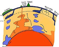
Columbus OH (SPX) Dec 30, 2008 Two giant plumes of hot rock deep within the earth are linked to the plate motions that shape the continents, researchers have found. The two superplumes, one beneath Hawaii and the other beneath Africa, have likely existed for at least 200 million years, explained Wendy Panero, assistant professor of earth sciences at Ohio State University. The giant plumes - or "superpiles" as Panero calls them - rise from the bottom of Earth's mantle, just above our planet's core. Each is larger than the continental United States. And each is surrounded by a wall of plates from Earth's crust that have sunk into the mantle. She and her colleagues reported their findings at the American Geophysical Union meeting in San Francisco. Computer models have connected the piles to the sunken former plates, but it's currently unclear which one spawned the other, Panero said. Plates sink into the mantle as part of the normal processes that shape the continents. But which came first, the piles or the plates, the researchers simply do not know. "Do these superpiles organize plate motions, or do plate motions organize the superpiles? I don't know if it's truly a chicken-or-egg kind of question, but the locations of the two piles do seem to be related to where the continents are today, and where the last supercontinent would have been 200 million years ago," she said. That supercontinent was Pangea, and its breakup eventually led to the seven continents we know today. Scientists first proposed the existence of the superpiles more than a decade ago. Earthquakes offer an opportunity to study them, since they slow the seismic waves that pass through them. Scientists combine the seismic data with what they know about Earth's interior to create computer models and learn more. But to date, the seismic images have created a mystery: they suggest that the superpiles have remained in the same locations, unchanged for hundreds of millions of years. "That's a problem," Panero said. "We know that the rest of the mantle is always moving. So why are the piles still there?" Hot rock constantly migrates from the base of the mantle up to the crust, she explained. Hot portions of the mantle rise, and cool portions fall. Continental plates emerge, then sink back into the earth. But the presence of the superpiles and the location of subducted plates suggest that the two superpiles have likely remained fixed to the Earth's core while the rest of the mantle has churned around them for millions of years. Unlocking this mystery is the goal of the Cooperative Institute for Deep Earth Research (CIDER) collaboration, a group of researchers from across the United States who are attempting to unite many different disciplines in the study of Earth's interior. Panero provides CIDER her expertise in mineral physics; others specialize in geodynamics, geomagnetism, seismology, and geochemistry. Together, they have assembled a new model that suggests why the two superpiles are so stable, and what they are made of. As it turns out, just a tiny difference in chemical composition can keep the superpiles in place, they found. The superpiles contain slightly more iron than the rest of the mantle; their composition likely consists of 11-13 percent iron instead of 10-12 percent. But that small change is enough to make the superpiles denser than their surroundings. "Material that is more dense is going to sink to the base of the mantle," Panero said. "It would normally spread out at that point, but in this case we have subducting plates that are coming down from above and keeping the piles contained." CIDER will continue to explore the link between the superpiles and the plates that surround them. The researchers will also work to explain the relationship between the superpiles and other mantle plumes that rise above them, which feed hotspots such as those beneath Hawaii and mid-ocean ridges. Ultimately, they hope to determine whether the superpiles may have contributed to the breakup of Pangea. Related Links Ohio State University Tectonic Science and News
 West Lafayette IN (SPX) Dec 11, 2008
Researchers have captured for the first time a geological event considered key in shaping the Earth's landscape. |
|
| The content herein, unless otherwise known to be public domain, are Copyright Space.TV Corporation. AFP and UPI Wire Stories are copyright Agence France-Presse and United Press International. ESA Portal Reports are copyright European Space Agency. All NASA sourced material is public domain. Additional copyrights may apply in whole or part to other bona fide parties. Advertising does not imply endorsement, agreement or approval of any opinions, statements or information provided by Space.TV Corp on any Web page published or hosted by Space.TV Corp. Privacy Statement |