|
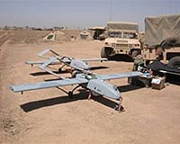
Baquba, Iraq (UPI) Jan 27, 2009 Some Iraqi military commanders may soon gain access to streaming surveillance and reconnaissance video from tactical U.S. unmanned aerial vehicles. Maj. Phillip Mann, commander of a Shadow-200 unit on Forward Operating Base War Horse, northeast of Baghdad in Diyala province, said efforts were under way to provide the real-time images to U.S. Military Transition Team advisers who in turn could show sanitized videos to their Iraqi partners. "All of us are in a tricky situation because of the SOFA -- Status of Forces Agreement," said Mann, of Delta Troop, 5th Squadron, 1st Cavalry Regiment. "Before it was just U.S. operations that we supported. Now we're going to have to transfer material to the Iraqis, and there's classified information involved. "We're already working to skim some of the data off of it to enable the Iraqis to see the images. We're not completely there yet, but right now the advisers who are with those Iraqi units are getting that capability to do that." The Shadow-200 is a lightweight unmanned aerial vehicle designed to give a commander streaming video reconnaissance, surveillance, target acquisition, and battle damage assessment. It weighs just 375 pounds, is about 11 feet in length and is made of composite materials. The Shadow-200's electronic package -- electro-optic cameras with infrared capability and lasers -- is fitted beneath the nose in a ball-shaped container that rotates 360 degrees. From heights ranging from 500 feet to 12,000 feet the Shadow UAV scans terrain and can zoom in on encountered situations of interest -- large movements of men or vehicles, for instance -- to specific targets of interest, such as a specific house or specific vehicle it has been tasked to monitor. On the screens in front of the Shadows' human controllers are the real-time, streaming video images the cameras are recording. On the edges of the screen are classified or secret data, such as telemetry, call signs of nearby aircraft, U.S. map grid designations and other system and flight information. Controlling it is an Air Vehicle Operator -- pilot -- and a Payload Officer -- the electronics wizard -- who sit in tandem amid joysticks, computers and television-like screens in a command center at the launching site. "You're looking from 7,000 or 8,000 feet through a soda straw. We may see something by chance or we may not see it," said Chief Warrant Officer 2nd Class David Wheatley, a Shadow operations technician. "It's not a stand-alone system, it has to have something else cueing it." Wheatley meant intelligence, which increasingly will become intelligence gathered by Iraqi security forces. U.S. troops, under the Status of Forces Agreement -- also called the Strategic Framework -- between Washington and Baghdad are now playing supporting roles in operations in Iraq, which means their daily direct interaction with local citizens and their intelligence sources is diminishing. Iraqi troops, who still use cell phones to communicate with each other and who perennially struggle with vehicle shortages, need the Shadow's images as well for over-watch, especially in rural regions such as Diyala province. Related Links UAV News - Suppliers and Technology
 Tampere, Finland (SPX) Jan 27, 2009
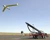
The continued evolution of advanced tactical class unmanned air systems (UAS) is showing a marked trend towards development of zero point launch as a capability standard according to Finnish unmanned air system launching specialist Robonic. |
|
| The content herein, unless otherwise known to be public domain, are Copyright Space.TV Corporation. AFP and UPI Wire Stories are copyright Agence France-Presse and United Press International. ESA Portal Reports are copyright European Space Agency. All NASA sourced material is public domain. Additional copyrights may apply in whole or part to other bona fide parties. Advertising does not imply endorsement, agreement or approval of any opinions, statements or information provided by Space.TV Corp on any Web page published or hosted by Space.TV Corp. Privacy Statement |