|
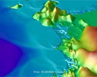
Bonn, Germany (SPX) Jul 15, 2008 After completing their simulation component in the German-Indonesian Tsunami Early Warning System (GITEWS), the team for tsunami modelling of the Alfred Wegener Institute for Polar and Marine Research in the Helmholtz Association has presented the currently leading software system for tsunami events with the potential for catastrophe. It is now being integrated into the Decision Support System (DSS) of the German Aerospace Center in Oberpfaffenhofen. It is to resume its test mode in Indonesia in November. "Within slightly more than two years, my team has developed, with the help of current software technology, the most modern and flexible simulation system for one of the most dreaded natural disasters of the world", explains Dr. Jorn Behrens, Head of the Tsunami Modelling Group of the Alfred Wegener Institute. "In contrast to other currently available Tsunami Early Warning Systems, it does not only use earthquake data for its ultra-fast situational analysis, but it combines various measurements to a robust, precise, and quick situation report." Next to seismic data (earthquake parameters), also gauge and buoy data (wave heights), and GPS data (deformations of the earth's crust) can be incorporated into the calculations. All these data run together in the DSS, and the picture of the general situation supports decision-makers - for example after a seaquake - to evaluate more reliably and quicker than before, whether it poses a threat for residents of the bordering coastline in the form of rising water waves. Accordingly, warnings reach affected persons earlier than before, and it leaves more time to take disaster prevention measures. Furthermore, simulation results from different institutes can seamlessly be integrated into the system. The team from the Alfred Wegener Institute will provide the warning system until November 2008 with already around 1500 high-resolution tsunami scenarios. The newly developed simulation system compares these scenarios with incoming real measurement data in a matter of seconds and deduces its forecast. The Indonesian partners work on the completion of the database at the same time. Together with colleagues from the Indonesian "Institute of Technology Bandung", a connection to approximately 160.000 local tsunami scenarios they calculated is now being incorporated into the system developed at the Alfred Wegener Institute in Bremerhaven. They allow an essential expansion of the database."In regard to the interface to other programs, we adhere to open standards, which control the exchange of data in the world of computers. This way, external scenarios can seamlessly be integrated, and we can adapt the simulation model quickly to other marine areas of the world, for instance the Mediterranean Sea," says Behrens about the perspective for further early warning systems. The Tsunami Modelling group consists of seven researchers and PhD students, among them one PhD student from Indonesia. It was established at the beginning of 2006, and has developed, next to the simulation system presented here, the simulation software TsunAWI, which is one of the bases for the computation of tsunami scenarios. The software has mastered its practical test: it computed the resulting wave heights precisely, when an earthquake of magnitude 7,9 near Bengkulu/Western Sumatra triggered a tsunami on September 13th 2007. The aim of GITEWS is to minimize the consequences of natural disasters by means of an early warning system. Nevertheless, a natural phenomenon like the tsunami in the year 2004 cannot be prevented, and catastrophes of this kind will always cause casualties, regardless of a perfectly working alarm system. GITEWS is developed by several scientists and engineers from the Helmholtz Centre Potsdam German Research Center for Geosciences (GFZ), the Alfred Wegener Institute for Polar and Marine Research in the Helmholtz Association (AWI), the German Aerospace Center (DLR), the Research Center in Geesthacht (GKSS), the German Marine Research Consortium (KDM), the Leibniz Institute of Marine Sciences (IFM-GEOMAR), the United Nations University (UNU), the Gesellschaft fur Technische Zusammenarbeit (GTZ), and the Federal Institute for Geosciences and Natural Resources (BGR), as well as Indonesian and international partners. The project is financed by the Federal Ministry of Education and Research (BMBF). Related Links Helmholtz Association of German Research Centres Bringing Order To A World Of Disasters When the Earth Quakes A world of storm and tempest
 Vienna (AFP) June 25, 2008
The body that oversees the Comprehensive Nuclear Test Ban Treaty offered its unique know-how Wednesday to countries thar ring the Pacific Ocean to warn them of killer tsunamis. |
|
| The content herein, unless otherwise known to be public domain, are Copyright Space.TV Corporation. AFP and UPI Wire Stories are copyright Agence France-Presse and United Press International. ESA Portal Reports are copyright European Space Agency. All NASA sourced material is public domain. Additional copyrights may apply in whole or part to other bona fide parties. Advertising does not imply endorsement, agreement or approval of any opinions, statements or information provided by Space.TV Corp on any Web page published or hosted by Space.TV Corp. Privacy Statement |