SPACE MART SPACE DAILY SPACE WAR TERRA DAILY MARS DAILY SPACE TRAVEL GPS DAILY ENERGY DAILY
  Space Industry and Business News  
Get Our Free Newsletters Via Email
  
Search All Our Sites at SpaceBank
Taiwan shares satellite images with China of quake disaster area

by Staff Writers
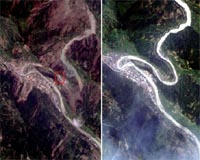
Taipei (AFP) May 15, 2008
Taiwan has provided rival China satellite images showing some areas devastated by the 7.9-magnitude earthquake in the mainland's southwest, officials and academics said Thursday.

The images showed Beichuan, one of the worst-hit areas in Sichuan province, in May 2006 and after Monday's disaster on Wednesday. The pictures revealed a large forest, school and clusters of residential houses along a river had been wiped out by the quake, and a road along the river was severely damaged.

"The images, which are free of charge, are expected to be used as references in China's efforts searching and rescuing the people still missing in Sichuan," Harry Chang, a professor of National Taiwan Normal University, told AFP.

Change said the images were collected by the FORMOSAT-2 satellite, a science research craft owned by Taiwan, and given to the Chinese Academy of Sciences.

Chang estimated that in Beichuan, the tremor also had caused landslides covering some 1,500 hectares (3,705 acres), which had blocked the river.

"Accordingly, several new lakes have been formed. What is dangerous is that should the new lakes burst, the residents living in the low-lying areas of the river would be in danger," he said.

Chang also warned of mudslides caused by rain, saying "it would make the rescue work more difficult."

Taiwan and China split in 1949 after a civil war, but Beijing still sees the island as part of its territory awaiting reunification, by force if necessary.

Community
Email This Article
Comment On This Article

Share This Article With Planet Earth
del.icio.usdel.icio.us DiggDigg RedditReddit
YahooMyWebYahooMyWeb GoogleGoogle FacebookFacebook


Related Links
Earth Observation News - Suppiliers, Technology and Application


Raytheon Reaches Key Milestone On NASA Glory Space Program
El Segundo CA (SPX) May 14, 2008
Raytheon has completed manufacture and testing of the optics detector module for the aerosol polarimetry sensor. The sensor will ride on the NASA Glory satellite to help agency and other federal officials better understand the impact of aerosols on global warming and climate change.


Memory Foam Mattress Review

Newsletters :: SpaceDaily Express :: SpaceWar Express :: TerraDaily Express :: Energy Daily
XML Feeds :: Space News :: Earth News :: War News :: Solar Energy News
  • Intelsat And Panasonic To Bring Broadband Service To The Skies
  • Google wins from end of Microsoft-Yahoo affair: analysts
  • Microsoft takeover deadline for Yahoo expires without comment
  • China world's largest Internet market

  • Arianespace Takes Delivery Of Its Third Ariane 5 In 2008
  • Orbital Awarded Contract for Suborbital Launch Vehicle Research by US DoD
  • Skynet 5C And Turksat 3A Are Fueled For The Upcoming Ariane 5 Heavy-Lift Launch
  • ISRO Scientists Meet With Prime Minister

  • China's new jumbo-jet firm no threat to Airbus, Boeing: state media
  • China unveils new jumbo jet company: report
  • NASA And JAXA To Conduct Joint Research On Sonic Boom Modeling
  • Analysis: Can airplanes go green?

  • Northrop Grumman Begins Installing New Engines On Joint STARS
  • Battlefield Airborne ComNode Enables Real-Time Distribution Of F-22 Data To Legacy Aircraft
  • Lockheed Martin Submits Bid For USAF Space Situational Awareness Program
  • GD Awarded Contract For Next-Gen Cryptographic Technologies

  • SMS Texting Costs Are Out Of This World
  • Raytheon Reaches Key Milestone On NASA Glory Space Program
  • Integral Systems Europe Announces EPOCH IPS Satellite Ground System PUS Compliance
  • Boeing Provides New Test Facility For Next-Gen Radar Technology

  • SES AMERICOM Announces Change In Executive Management
  • Bill Flynn Joins Americom Government Services to Lead Navy Programs
  • NASA names science directorate deputy
  • Northrop Grumman Names Terri Zinkiewicz VP Sector Controller For Its Space Technology Sector

  • Taiwan shares satellite images with China of quake disaster area
  • Raytheon Reaches Key Milestone On NASA Glory Space Program
  • USGS Awards Satellite Imagery Contracts: Enhancing Access To Users
  • Bluesky Launches 3D Computer Models Of Britain's Cities

  • EU gives green light to TomTom takeover of Tele Atlas
  • mojoRTK Steers CCD Tractors With the John Deere GreenStar System
  • Hi-G-Tek Partners With Emco Wheaton To Supply RFID Solutions For Fuel Industry
  • Spirent Communications and CTTL Partner Up On Assisted GPS Testing For China

  • The content herein, unless otherwise known to be public domain, are Copyright 1995-2007 - SpaceDaily.AFP and UPI Wire Stories are copyright Agence France-Presse and United Press International. ESA Portal Reports are copyright European Space Agency. All NASA sourced material is public domain. Additional copyrights may apply in whole or part to other bona fide parties. Advertising does not imply endorsement,agreement or approval of any opinions, statements or information provided by SpaceDaily on any Web page published or hosted by SpaceDaily. Privacy Statement