|
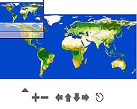
Paris, France (ESA) Mar 18, 2008 A new global portrait taken from space details Earth's land cover with a resolution never before obtained. ESA, in partnership with the UN Food and Agriculture Organisation, presented the preliminary version of the map to scientists last week at the 2nd GlobCover User Consultation workshop held in Rome, Italy. Earth's land cover has been charted from space before, but this map, which will be made available to the public upon its completion in July, has a resolution 10 times sharper than any of its predecessors. Scientists, who will use the data to plot worldwide land-cover trends, study natural and managed ecosystems and to model climate change extent and impacts, are hailing the product - generated under the ESA-initiated GlobCover project - as 'a milestone.' "The GlobCover system is a great step forward in our capacities to automatically produce new global land cover products with a finer resolution and a more detailed thematic content than ever achieved in the past," Frederic Achard of the European Commission's Joint Research Centre (JRC) said. "This GlobCover product is much more than a map. It is an operational scientific and technical demonstration of the first automated land cover mapping on a global scale and may provide the detailed description of the land surface states needed for regional climate modelling," said Prof. Pierre Defourny, from the Universite catholique de Louvain, who designed the land classification process. "Land cover data is an essential requirement of the sustainable management of natural resources, environmental protection, food security, climate change and humanitarian programmes," John Latham of the Food and Agriculture Organisation (FAO) said. "The GlobCover product will be the first freely available product at 300m resolution and is therefore a milestone product which will be fundamental to a broad level stakeholder community." Jaap van Woerden from the United Nations Environment Programme (UNEP) said: "This map can greatly support the work of UNEP and partners in addressing environmental priority issues such as climate change and ecosystem management." Prof. Christiane Schmullius from the University of Jena in Germany said the new GlobCover product "revolutionises global land cover mapping." The map is based on 20 Terabytes of imagery - equivalent to the content of 20 million books - acquired from May 2005 to April 2006 by Envisat's Medium Resolution Imaging Spectrometer (MERIS) instrument. All images then undergo a standardised processing technique developed and operated by Medias-France/Postel, together with Brockmann Consult, the Universite catholique de Louvain and partners. There are 22 different land cover types shown in the map, including croplands, wetlands, forests, artificial surfaces, water bodies and permanent snow and ice. For maximum user benefit, the map's thematic legend is compatible with the UN Land Cover Classification System (LCCS). GlobCover, launched in 2005, is part of ESA's Earth Observation Data User Element (DUE). An international network of partners is working with ESA on the project, including the UN Environment Programme (UNEP), FAO, the European Commission's Joint Research Centre (JRC), the European Environmental Agency (EEA), the International Geosphere-Biosphere Programme (IGBP) and the Global Observations of Forest Cover and Global Observations of Land Dynamics (GOFC-GOLD) Implementation Team Project Office. Related Links GlobCover Earth Observation News - Suppiliers, Technology and Application
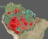 Rio De Janeiro, Brazil (XNA) Mar 18, 2008
Brazil and Germany have signed an agreement to develop a night-vision radar satellite to observe the Amazon region, the National Space Research Institute (INPE) said Sunday. The INPE plans to build the Multiple Application Synthetic Aperture Radar with the help of the German Space Center over 18 months, in the second satellite project undertaken by the two nations. |
|
| The content herein, unless otherwise known to be public domain, are Copyright Space.TV Corporation. AFP and UPI Wire Stories are copyright Agence France-Presse and United Press International. ESA Portal Reports are copyright European Space Agency. All NASA sourced material is public domain. Additional copyrights may apply in whole or part to other bona fide parties. Advertising does not imply endorsement, agreement or approval of any opinions, statements or information provided by Space.TV Corp on any Web page published or hosted by Space.TV Corp. Privacy Statement |