SPACE MART SPACE DAILY SPACE WAR TERRA DAILY MARS DAILY SPACE TRAVEL GPS DAILY ENERGY DAILY
  Space Industry and Business News  
Get Our Free Newsletters Via Email
  
Search All Our Sites at SpaceBank
NASA Views Southern California Fires And Winds

Smoke from multiple wildfires burning in Southern California, together with dust in Southern California, Baja California and mainland Mexico, swirl out into the Pacific and Gulf of California, respectively, in this false-color visible image from the Atmospheric Infrared Sounder on NASA's Aqua satellite, acquired at about 7 p.m. Eastern Time on October 22. Strong Santa Ana winds are fanning the wildfires, among the most destructive in recent memory. Image Credit: NASA/JPL
by Staff Writers
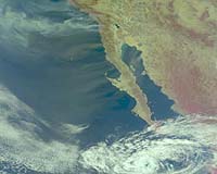
Moffett Field CA (SPX) Oct 24, 2007
With a click of the mouse button, the public can see NASA views from space, including some at Google Earth, of Southern California's raging wildfires and the ferocious Santa Ana winds that are driving them.

Images taken by the Moderate Resolution Imaging Spectroradiometer (Modis) on NASA's Terra and Aqua satellites are processed daily and made available by the JPL OnEarth Web Map Server, and at Google Earth. This effort is part of an ongoing collaboration with JPL, Google Earth, and NASA Ames Research Center, Moffett Field, Calif., to make remote satellite imagery available to the public and decision makers. Latest Modis fire images at onearth.jpl.nasa.gov/socalfires

NASA Goddard Space Flight Center in Greenbelt, Md., manages Aqua and Terra. Images from the NASA/JPL QuikScat satellite and Airs instrument on the Aqua satellite show the winds' powerful path.

Community
Email This Article
Comment On This Article

Related Links
Earth Observation News - Suppiliers, Technology and Application


A Roadmap For Calibration And Validation
Geneva, Switzerland (SPX) Oct 23, 2007
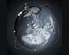
The volume of data acquired by more than 50 Earth Observation satellites is increasing at an exponential rate and is providing unprecedented synoptic views of our planet. Because these satellites often use different methodologies, using data for trend analysis and environmental monitoring can be difficult, making it essential to establish globally recognised guidelines for Calibration and Validation processes.


Memory Foam Mattress Review

Newsletters :: SpaceDaily Express :: SpaceWar Express :: TerraDaily Express :: Energy Daily
XML Feeds :: Space News :: Earth News :: War News :: Solar Energy News
  • Google revs up profits as advertising revenues soar
  • Internet preparing to go into outer space
  • US cities' Wi-Fi dreams fading fast
  • Digital Dandelions: The Flowering Of Network Research

  • Successful Ariane 5 Upper Stage Engine Re-Ignition Experiment
  • ILS Proton Launch Scheduled In November For SES SIRIUS 4 Satellite
  • United Launch Alliance Managed Delta 2 Launches New GPS For US Air Force
  • ATK Propulsion And Composite Technologies Help Launch GPS Satellite

  • Solar Telescope Reaches 120,000 Feet On Jumbo-Jet-Sized Balloon
  • Third Maritime Surveillance System For Canada
  • Airbus US boss demands end to WTO "histrionics"
  • MEPs seek limits on aircraft emissions by 2010

  • Northrop Grumman Introduces New Geospatial Data Appliance For Defense And Intelligence Operations
  • Raytheon JPS Communications Collaborates With Cisco To Provide Interoperability Solution
  • Boeing Awarded Contract To Integrate F-22 Into UAF Distributed Mission Operations Training Network
  • Raytheon Sensor Netting Technology Contract

  • MIT Gel Changes Color On Demand
  • GKN Aerospace And FMW Composite Systems Combine For First Use Of TMMC Material On A Commercial Aircraft Programme
  • Special vest lets players feel video game blows
  • Radyne's AeroAstro To Upgrade Globalstar's Messaging Capacity

  • Dr Mary Cleave Appointed To Board Of Directors Of Sigma Space
  • Boeing Names Scott Fancher Missile Defense Systems VP And GM
  • Northrop Grumman Appoints GPS And Military Space VPs
  • CNP Powers Up Advanced Technology Suite To Improve Selection Board Process

  • NASA Views Southern California Fires And Winds
  • A Roadmap For Calibration And Validation
  • Key Found To Moonlight Romance
  • GeoEye Contract With ITT Begins Phased Procurement Of The GeoEye-2 Satellite

  • Another GPS Satellite Successfully Launched
  • Science And Galileo - Working Together
  • Modernized GPS Built By Lockheed Martin Ready For Launch From Cape Canaveral
  • Krasnoyarsk Hosts GLONASS Development Conference

  • The content herein, unless otherwise known to be public domain, are Copyright 1995-2006 - SpaceDaily.AFP and UPI Wire Stories are copyright Agence France-Presse and United Press International. ESA PortalReports are copyright European Space Agency. All NASA sourced material is public domain. Additionalcopyrights may apply in whole or part to other bona fide parties. Advertising does not imply endorsement,agreement or approval of any opinions, statements or information provided by SpaceDaily on any Web page published or hosted by SpaceDaily. Privacy Statement