SPACE MART SPACE DAILY SPACE WAR TERRA DAILY MARS DAILY SPACE TRAVEL GPS DAILY ENERGY DAILY
  Space Industry and Business News  
Get Our Free Newsletters Via Email
  
Search All Our Sites at SpaceBank
Boeing Launches WorldView-1 Earth-Imaging Satellite

File image of DigitalGlobe WorldView-1 satellite.
by Staff Writers
St. Louis MO (SPX) Sep 18, 2007
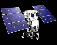
Boeing, through its commercial launch business, successfully launched the WorldView-1 satellite for DigitalGlobe aboard a Delta II rocket. Lift-off occurred at 11:35 a.m. Pacific time from Pad SLC-2W at Vandenberg Air Force Base, Calif. The Delta II rocket deployed the spacecraft approximately 73 minutes after lift-off. The WorldView-1 satellite will provide commercial, high-resolution images of Earth, and is capable of collecting, storing and down-linking more frequently updated imagery than any other commercial imaging satellite in orbit.

"Today's launch of WorldView-1 marks our second successful commercial launch for Boeing Launch Services in 2007 and puts us on track for a very successful year with two of our three scheduled launches completed," said Ken Heinly, vice president of Boeing Launch Services.

The launch also marks the 75th consecutive successful launch of a Delta II rocket. Boeing designed the "workhorse" launch vehicle and operated it until Dec. 1, 2006, when the United Launch Alliance joint venture between Boeing and Lockheed Martin was formed to support the U.S. government. Boeing Launch Services purchased the launch vehicle and associated support services from United Launch Alliance.

Community
Email This Article
Comment On This Article

Related Links
Earth Observation News - Suppiliers, Technology and Application


New Faraway Sensors Warn Of Emerging Hurricane's Strength
Pasadena CA (SPX) Sep 10, 2007
Days before a growing hurricane possibly batters a local coastline, meteorologists rush to predict just how strong its winds and rains may grow knowing that lives and an area's economy may depend on their results. A new study supported by NASA and the U.S. Office of Naval Research takes forecasters one step further to improving their ability to predict just how powerful an oncoming storm may become by using highly-sensitive sensors located thousands of miles from the storm to detect lightning outbreaks within a hurricane's most dangerous area.


Memory Foam Mattress Review

Newsletters :: SpaceDaily Express :: SpaceWar Express :: TerraDaily Express :: Energy Daily
XML Feeds :: Space News :: Earth News :: War News :: Solar Energy News
  • Digital Dandelions: The Flowering Of Network Research
  • Researchers Aim To Make Internet Bandwidth A Global Currency
  • Controlling Bandwidth In The Clouds
  • NKorea to get Internet code

  • Russian Space Launch Vehicle Firing Tests Set For 2008
  • Arianespace To Launch Japanese Satellite JCSAT-12
  • United Launch Alliance Launches 75th Consecutive Delta II On USAF 60th Anniversary
  • Pratt And Whitney Rocketdyne's RS-27A Powers New-Gen Imaging Satellite To Orbit

  • Cathay Pacific chief hits out at anti-aviation critics
  • Boeing Projects 340 Billion Dollar Market For New Airplanes In China
  • Squabble over airline carbon emissions takes flight
  • NCAR Teams With United Airlines To Pinpoint Turbulence In Clouds: Research Can Help Reduce Delays, Injuries, Costs

  • China's military tests sophisticated real-time data system
  • ThalesRaytheonSystems To Provide Upgrade For Battle Control System
  • Northrop Grumman Receives Major Contract For Guardrail Modernization
  • Boeing Demonstrates FAB-T Interoperability With Milstar Satellite

  • SSC Communication System Flys On Russian Capsule Foton
  • Engineers Rescue Aging Satellites And Save Millions
  • Russian Satellites: Smaller, Lighter, Cheaper
  • INSAT-4CR Raised To A Perigee Of 15994 Kilometers

  • Analysis: Sulick new head spy for CIA
  • Raytheon Names Dr. Thomas Kennedy VP Tactical Airborne Systems
  • Northrop Grumman Appoints James Myers VP And GM Of Navigation Systems Division
  • Senior Official Of Energia Space Appointed President

  • Boeing Launches WorldView-1 Earth-Imaging Satellite
  • New Faraway Sensors Warn Of Emerging Hurricane's Strength
  • Key Sensor For Northrop Grumman NPOESS Program Passes Critical Structural Test
  • Air France And ESA Join To Offer Passengers Unique View Of Voyage

  • DoD Permanently Discontinues Procurement Of Global Positioning System Selective Availability
  • Brussels to present finance plans to save Galileo satnav project
  • Boeing Builds First GPS IIF Satellite
  • Lockheed Martin Team Shifts Into Production Effort To Add GPS Demonstration Signal To Modernized Satellite

  • The content herein, unless otherwise known to be public domain, are Copyright 1995-2006 - SpaceDaily.AFP and UPI Wire Stories are copyright Agence France-Presse and United Press International. ESA PortalReports are copyright European Space Agency. All NASA sourced material is public domain. Additionalcopyrights may apply in whole or part to other bona fide parties. Advertising does not imply endorsement,agreement or approval of any opinions, statements or information provided by SpaceDaily on any Web page published or hosted by SpaceDaily. Privacy Statement